Tuesday, April 8, 2014

Day hiking Black Creek Wilderness and Red Hills in De Soto National Forest in Mississippi


Black Creek Trail between Melvin Breland Rd and Red Hills Cemetery
       When hikers hear of the 41-mile Black Creek Hiking Trail in Mississippi's De Soto National Forest, about a two-hour drive northeast of New Orleans, right away they want to hike the whole thing in one trip.  They think: Start at Big Creek Landing, hike southeast to Cypress Creek Landing, the trail's eastern terminus.  Takes four to five days.  Done.  Next!
        But not everybody has the kind of time or even interest to take the Magnolia State's longest hiking trail in one big bite.  Fortunately for the rest of us, Black Creek Hiking Trail can be broken into much shorter chunks suitable for weekend backpacking or even day hiking using car shuttles to connect various trailheads along the trail.
        Shuttles?  The only problem with hiking the Black Creek Trail is that it is linear.  No loops.  So any distance you hike one-way on the trail, from five miles to the whole 41 miles, will require either turning around and retracing your steps or at least two cars, one parked at the start and one at the finish, to complete the trip.
       After accepting this one negatory, you will find Black Creek Trail has some lovely short hikes that match any level of interest in exploring up close and personal the Piney Woods region of southeast Mississippi.  Each season has its pluses and minuses.  Summer is hot, humid and buggy.  In winter deer hunting takes place from late November to the end of January.  The website: mdwfp.com, has all the hunting seasons in the national forest.  Spring is very nice, the weather is good and the wildflowers are in bloom.  Fall is also nice, October and November are the driest months.  Always pack insect repellent especially in the late spring, summer and fall to repel deer flies, deer ticks and mosquitoes.
        Many experienced hikers say the 5058-acre Black Creek Wilderness and/or the adjoining rugged Red Hills offer the most scenic hikes in the entire 382,000 acre De Soto National Forest.   Black Creek Wilderness, about a two-hour drive northeast of New Orleans, is the closest federally designated wilderness area to the Crescent City.
       "Parts of the trail in the wilderness area are gorgeous, if you know where to look," said Robert Reams, a veteran hiker who has hiked portions of Black Creek Trail many times as part of his job as archaeologist with the De Soto National Forest's De Soto Ranger District based in Wiggins, MS.
      Black Creek Hiking Trail twists and turns 10.8 miles through the pristine wilderness.  Heading west to east hikers enter the wilderness area from the trailhead on highway MS 29 near Janice Landing and Black Creek.  The trail is well marked with white diamonds nailed to the trees.  But machinery and wheeled vehicles are prohibited in federal wilderness areas so all trail maintenance must be done manually with hand tools.  This leaves the trail a bit rugged as big chores, such as removing large trees that have fallen across the trail, apparently are a low priority. 
      "It took us almost three years to reopen this section of the Black Creek Trail after hurricane Katrina in 2005," said Reams.  Black Creek Hiking Trail, both inside and outside the wilderness area is maintained by a contractor.  Pruning and cutting is done every two to three years as needed.  If the trail looks especially trimmed this year it is because the trail was recently groomed, Reams said.
      
     
The walk around Beaver Creek, in the wilderness, is especially scenic though there is access to the creek only on its eastern bank.  Leaving the confluence of Beaver Creek and Black Creek, the trail courses through a hardwood flood plain of red maple, oak, pine and bald cypress.  The bridge at Mill Creek, a creek too wide to jump across, is out.  Hikers have to wade across the shallow creek or brave balancing on a log above it to cross.  After Mill Creek the trail then turns south and gently rises onto a piney flat at the eastern edge of the wilderness at Melvin Breland Rd. (FS 382B).  There is parking here for about three to five cars at an undeveloped dirt pull-out.
       (Searching the Internet will return several references to parking and access to the trail at St. Andrews Church on Florida Gas Road, often mistakenly identified as New York Rd. That may have been true 20 years ago but not now. Now the "church" grounds are festooned with menacing no trespassing signs and the satellite dishes on the building are a good indication that the building is now used as a home. Topo maps of the area show the building and grounds sit within national forest property lines but Reams said even a public employee in a marked vehicle would be taking a risk parking there for any reason.)
        Melvin Breland Rd. marks the eastern boundary of the wilderness. Continuing east after crossing the road the trail changes dramatically, widening to about 10 feet.  The forest highland becomes more open with fewer tall trees and more bushy understory.  The opening of the tree canopy is in part due to the severe toll the high winds of Hurricane Katrina took on trees in De Soto.  Also, now outside the wilderness area,  the trail can be maintained with power tools and motorized equipment carts. 
      Right after crossing Melvin Breland Rd. he trail drops gradually from the piney highlands down to the flood plain, 10-15 feet above Black Creek flowing at the edge of a steep cutbank  The only access to the creek here is a well-worn, short unsigned spur leading to a sad narrow sandbar which looks like it is eroding away.  But on a hot day any access to the cooling waters of the creek would be welcome.
      Right after the spur to the sandbar, the trail veers sharply to the west southwest leaving the shade of the hardwood flood plain and enters the more open Red Hills.  That is when things become challenging.  For the next two miles steep climbs--straight up, there are no switchbacks--of about 100 vertical feet will have some hikers on their toes and breathing heavily as they crest each hilltop.  Just as steep are the descents to the valley floor where wooden foot bridges cross small, clear creeks.  The clear rivulets, some named on the map, some not, tumble, bubble and burble over the sandy stream beds splotched tan, dark brown and olive.
     From Melvin Breland Rd. to where FS 318B-1 crosses the trail near Red Hill Cemetery only about 3.5 trail miles but the shuttle distance is much longer.  Where the trail crosses FS 318B-1 is space for a few vehicles to park.  Hikers parking here can make a nice out-and-back hike through the hills.  Head north. 
       From Red Hill Cemetery the trail tracks southeast and gradually looses elevation as the hills level out and the path returns to the flood plain.  Here the trail might be wet after a rainy spell.  The eastern terminus of Black Creek Hiking Trail is Fairley Bridge Landing, a primitive campground 2.6 miles from Red Hill Cemetery.  At Fairley Bridge there is a vault toilet and a few picnic tables but no potable water.
       Shuttles can be arranged with Black Creek Canoe Rental in Brooklyn, MS, (601) 582-8817, and Red Wolf Wilderness Adventures, (601) 598-2745, near the Janice trailhead.  Remember that cell phone service in this area is spotty.
       Despite the scenery and the unusually hilly terrain, the Wilderness Area and the Red Hills do not seem to be as popular with hikers as other sections of Black Creek Trail, Reams said.  WildSouth, an environmental advocacy group is helping to make the wilderness area more popular.  Beginning in 2012, both seasonal workers and volunteer wilderness rangers, trained by WildSouth have been walking the trail in the Black Creek Wilderness Area educating wilderness visitors, monitoring recreational resources and collecting visitor use data in addition to performing light trail maintenance and picking up litter, according to their website www.wildsouth.org.
       The volunteers have the blessing of the US Forest Service and carry US Forest Service radios.  The volunteers are trained in first aid and CPR, the website states.  They also offer assistance on the 21-mile stretch of Black Creek designated a Wild and Scenic River.
     Note:  The only drinking water available near the trail is at Janice Landing, across Black Creek from the Janice trailhead on highway MS 29.  No alcohol is permitted in any of the De Soto National Forest campgrounds.  No glass is permitted on the creeks.  The small free campground by the highway also has a flush toilet and small sink.  There is no drinking water at the Fairley Bridge Landing a primitive campground at the southeastern terminus of Black Creek Hiking Trail.  Water taken from streams along the trail must be treated, boiled or filtered before consuming

Maps

     The USGS topgraphical maps covering this part of the De Soto National Forest are Bond Pond and Barbara.  You can download 1:24000 scale maps for free from https://store.usgs.gov/.   You can order topos printed in full color from the site too. If you download and print, to maintain the 100 percent size of the map you will end up with nine sheets of 8.5" by 11" paper that will need to be carefully cut and taped together.  To make it easier to draw UTM grids download complete maps.  Once on the trail a black and white downloaded topo is much, much better than nothing.  If you are not in a hurry ordering the printed maps might be a good idea and save a little time.
      Maps are also available from the US Forest Service District Office in Wiggins, MS.  Call 601-528-6160 or write De Soto National Forest, P.O. Box 248, 654 West Frontage Road, Wiggins, MS  39577.  There are two: an 8.5 by 11 map of the entire Black Creek Hiking Trail with the distances between trailheads printed on the map and a larger scale map printed on one sheet of 11" by 17" paper, but no trail distances.   The larger map is better at showing the road system making it useful for finding your way for shuttles and to the campgrounds along Black Creek which are also access points for paddlers.  Both maps are free, at least they were free when I picked up mine  at the district office.  Also ask for the De Soto Ranger District Recreation Opportunities booklet which describes the features and facilities of each campground.  And for some scary reading ask for "Alligator Awareness in Mississippi." by the Mississippi Department of Wildlife Fisheries and Parks.  The gator population has exploded in Mississippi and these fearsome reptiles have begun to appear in streams that before had none.
     I hear an updated 1:24000 scale map is now in the works.  It may not have as much detail as the much beloved Black Creek topo map dated 1988 and printed on waterproof paper but it will be a welcome addition to the smaller two ink jet generated maps now available.  The new map might be ready by the end of 2014.  Drop a comment to the folks in Wiggins that you want to make sure there are UTM tics in the margins.  Or better yet, maybe a complete UTM grid!
 

Sunday, April 6, 2014

Bike to Work Day in New Orleans set for Tuesday, April 8, 2014

       Scheduled for April 8, Bike to Work Day in New Orleans was postponed one day because wet weather was forecast for the morning of April 8.   It was held the following day, April 9, a day of brisk winds, morning temperatures in the low 60's and brillant blue skies.
         There seemed to be a smaller turnout this year than last year.  Participants gathered on the Camp St. side of Lafayette Square Park around two tents:  One with breakfast of huge fresh muffins and Community coffee and a second tent for recruiting new Bike Easy members, the non-profit bicycle advocacy group holding Bike to Work Day.  Entergy is a major sponsor of Bike to Work Day and Patty Riddlebarger, the Director of Social Responsibility for Entergy Corp. was there chatting up bicycle commuting participants.
-30-
             
       If bicycling to work is on your bucket list, Tuesday, April 8 is the day to make it happen.  After your pedal into the city, join dozens of like-minded bicycle commuters after their ride into town for coffee and breakfast, 8:00am to 9:30am, in Lafayette Square Park in the CBD.  Riders can ride solo or join groups leaving at 7:30am for the ride to the square

Bike to Work Day in New Orleans, 2012
 from about half a dozen neighborhood staging areas in Mid-City, Lakeview, Uptown, the French Quarter and the Marigny.
       The ride is a project of Bike-Easy, a non-profit bicycle advocacy organization.  The event is sponsored by Entergy and is free.  For more information and a map of the neighborhood staging areas visit bikeeasy.org.  

Thursday, April 3, 2014

De Soto NF celebrates passage of the Wilderness Act 50 years ago with hike, creek cleanup and paddle trip through Black Creek Wilderness

ADDED APRIL 9, 2014
       PREREGISTRATION IS STRONGLY RECOMMENDED.  EVERYTHING STARTS VERY EARLY IN THE MORNING.  DO YOU REALLY WANT TO BOTHER WITH REGISTRATION WHEN YOU ARE THAT SLEEPY?  PHONE 601-528-6160, ASK FOR MARILYN.
       AFTER THE CHALLENGES THERE WILL BE A PARTY AT RED WOLF WILDERNESS ADVENTURES, ON MS 29 SOUTH OF JANICE LANDING.  A BAND, HOTDOGS AND SNACKS.  BAND BEGINS AT 1:30 P.M.  A BLUES BAND.
       REMEMBER: CANOES FOR THE TRIP ON BLACK CREEK MUST BE RESERVED AND PAID FOR BEFORE THE TRIP.  CONTACT BLACK CREEK CANOE RENTAL IN BROOKLYN, MS; 601-582-8817 or RED WOLF WILDERNESS ADVENTURES ON MS 29 NEAR THE JANICE LANDING NORTH OF WIGGINS; 601-598-2745.
        THE NORTH END OF ASHE NURSERY, OFF HIGHWAY US 49, HAS BEEN ADDED AS A CLEANUP SITE.
         SNACKS WILL BE AVAILABLE FOR BOTH THE HIKE THROUGH THE WILDERNESS AREA AND THE PADDLE ON BLACK CREEK.  JUST THE SAME YOU SHOULD ARRIVE AT EACH CHALLENGE START WITH SNACKS AND WATER OF YOUR OWN JUST IN CASE.  WEAR STURDY SHOES, SNEAKERS OR WATER SHOES IF YOU ARE GOING PADDLING.  IN A GARBAGE BAG STUFFED IN A PACK OR DRY BAG BRING RAIN GEAR AND EXTRA CLOTHING IF YOU ARE GOING CANOEING.  YOUR PHONE AND CAMERA SHOULD BE IN DRY BAGS OR CASES PROVEN BY YOU TO BE WATERPROOF, NOT BAGGIES OR ZIP LOCKS!!!  NO GLASS ON THE CREEK.  DO NOT TAKE YOUR CAR KEY OR THE LITTLE ELECTRONIC DOODAD THAT OPENS THE DOOR WITH YOU ON THE CREEK.  THEY BOTH SINK.
-jc   
      To celebrate the passage of the Wilderness Act 50 years ago, the De Soto National Forest, south of Hattiesburg, MS will hold a Wilderness Challenge Day, April 19, 2014.  Participants will have the opportunity to hike 10.5 miles (or less) through the 5050 acre Black Creek Wilderness or paddle a canoe on Black Creek, a National Scenic River, through the wilderness.  There is also an option to join a cleanup crew to freshen up the banks of Black Creek.

Black Creek as it begins its run
 through the Black Creek Wilderness.
 

     Registration will be held at the Black Creek Trail's Janice Trailhead on MS 29 near Black Creek.  Registration is free but there will be a charge to rent a canoe for the creek trips.  Everyone is expected to come prepared for a day in the wilderness and provide their own water, food and snacks, rain gear, comfortable shoes, and for those on the paddle trip, a dry bag with extra clothing.
     For more information email msstone@fs.fed.us.  The headquarters for the De Soto National Forest is in Wiggins, MS.  The telephone number is 601.528.6160.
     The National Wilderness Preservation System, created when the Wilderness Act of 1964 was signed into law fifty years ago, provided the legal mechanism for Congress to approve wilderness areas in federally owned lands.  Now, nearly 110 million acres of federally owned land is set aside in 756 wilderness areas--five percent of the total land area of the United States.
       The Black Creek Wilderness was approved by Congress in 1984.  Mississippi has two other federal wilderness areas; the Leaf Wilderness also in the De Soto National Forest and land in the Gulf Islands National Seashore. In Louisiana there are also three: Breton Island, the Kisatchie Hills Wilderness and the Lacassine Wilderness.
        "Where man himself is a visitor who does not remain," is a founding principle of establishing wilderness areas.   No motorized or mechanized devices are permitted in wilderness areas including vehicles, motor bikes and as of 1986, no bicycles.  (No bicycles are permitted on Black Creek Trail.)  The absence of human impact in wilderness areas makes them popular with hikers seeking to really get away from it all. The stretch of the Black Creek Recreation Trail running through the wilderness is said to be the most scenic and serene of the 41-mile trail.
-30- 

Thursday, March 27, 2014

Canal St.-Algiers Point ferry service cuts trips, charges $2 fare each way

      
      For years, taking the ferry from Canal Street (New Orleans, LA) across the Mississippi River to absorb some of the turn-of-the-century small town vibe of Algiers Point, has been a favorite excursion for pedestrians and bicyclists seeking a brief respite from the nonstop partying in New Orleans.
       The free trip across the river offered the best views of the New Orleans city skyline and in summer the often breezy mini-cruise offered a way to beat the tropical heat of a summer's evening.
       The views and the breezes are still there, but drastic cuts in ferry service hours and the establishment of a $2 fare, each way, has changed the way this sublime amusement is appreciated by the cult of the self-propelled.  Gone are the days when, broke and on a whim, you could visit Algiers to sight-see, groove to a festival or compete in quiz night at a cozy Algiers Point bar knowing that unless you stayed way past your bedtime, a ferry would be there to bring you to your home across the Mississippi.
       Now, visiting Algiers as a pedestrian or bicyclist via the ferry requires a willful decision and a working knowledge of the ferry schedule to void being stranded for the night on the wrong shore.
       Here is that all important schedule, from the nolaferries.com web site.  During the daily ferry schedule, ferries leave Canal St. every 30 minutes: on the hour and on the half hour.  Ferries leave Algiers Point a quarter (15 minutes) before the hour and a quarter (15 minutes) after the hour.  The trip takes about five minutes.  No food or drink is available on the ferry or at ferry terminals.
     Monday-Thursday:  The first ferry of the day leaves Algiers at 7:15 am.  It arrives at the foot of Canal St and leaves for the return trip to Algiers point at 7:30 am.  The last ferry leaves Algiers at 6:15 pm.  The last ferry leaves Canal St. at 6:30 pm.
     Friday:  The first ferry leaves Algiers at 7:45 am.  The first ferry leaves Canal St at 7:30 am.  The last ferry leaves Algiers 7:45 p.m. and the last ferry leaves Canal St. at 8:00 p.m.
     Saturday: The first ferry leaves Algiers at 10:45 am and the first ferry leaves Canal St. at 11:00 am.  The last ferry leaves Algiers at 7:45 p.m. and the last ferry leaves Canal St. at 8:00 pm.
     Sunday:  The first ferry leaves Algiers at 10:45 am.  The first ferry leaves Canal St. at 11:00 am.  The last ferry leaves Algiers at 5:45 pm and the last ferry leaves Canal St. at 6:00.
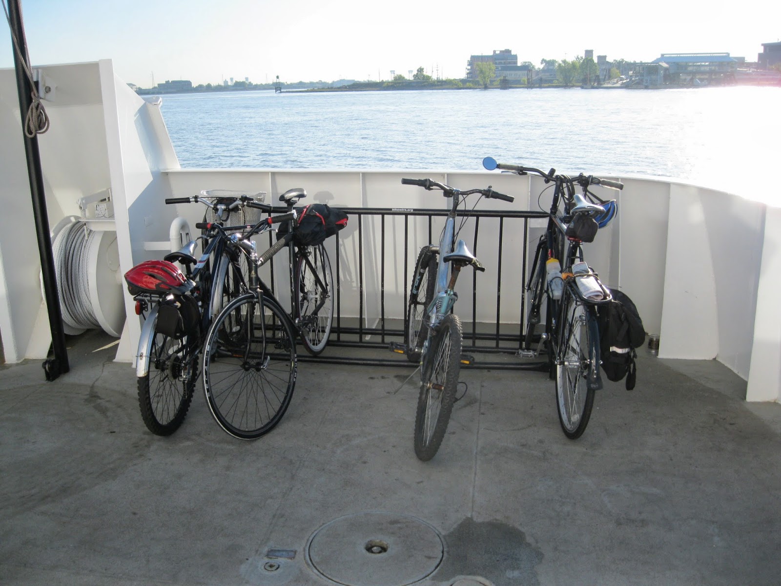
       The ferries are fairly reliable but if the river is foggy, they ferries stop running.  Board the ferry by walking your bike to the ferry outside the terminal on the metal grate down to the ferry.  DO NOT RIDE YOUR BIKE ON THE METAL GRATE!
     (Note: Veolia Transportation, the private for-profit company hired by the New Orleans Regional Transit Authority (RTA) to run the city's buses and now the pedestrian/bicycle ferry at Canal St. and the car ferry downriver at Chalmette, extended ferry operation hours considerably to accommodate Mardi Gras revellers.  It might do the same for other large events such as the French Quarter Festival and Jazzfest.  Log on to the NORTA site: www.nolaferries.com for the latest schedule changes.)
      In late February of this year, pedestrians, bicyclists and scooter drivers began to pay a $2 fare for a one-way trip.  Have correct change, each way.  Cars are no longer carried on the ferry.  Even though the ferry and the buses and streetcars are now managed by the same agency, bus/streetcar transfers are not valid for ferry trips.  (Because of the narrow passageways on the passenger ferry, no motorcycles are allowed on the ferry; only scooters.)  Pets are OK.
     You don't have to be a rocket scientist to figure out that even with the slightly extended ferry scheduling on Friday and Saturday nights sampling the nightlife of one side of the river if you live on the other and depend on the ferry for transportation is not in the cards.
      But if after a night of too much fun you find yourself stuck on the wrong side of the river after the ferries shut down for the evening, it's not the end of the world.  You can take the bus.  The RTA bus crossing the river to New Orleans from Algiers is the 101 Algiers Loop bus.  The bus stop closest to the ferry landing is at the corner of Verret and Pelican and the last bus leaves at 9:49 pm.  (There is an old abandoned Gulf service station at that corner.) The fare is $1.25.  The trip takes about 30 minutes and arrives at Elk Place and Canal St.
       Each RTA bus has a bicycle rack that holds two bicycles on the front of the bus. First come, first serve. You load the bike yourself. No extra charge for the bike.   Visit the RTA web site at www.norta.com for instructions on how to load your bicycle on the bike rack on the front of the bus.
       The bus stop at the ferry landing is for the 106 Algiers Local.  Do not take this bus.  It does not go to the East Bank and New Orleans.  It just makes loops around Algiers on the West Bank.
      Missed the bus?  Time to call a taxi.  Make sure the taxi service knows you have bicycle you want to bring.  The trip will not be cheap but it will be cheaper than spending the night in a bed and breakfast waiting for ferry service to resume in the morning.  Either way, next time you will pay more attention to when your ship leaves the dock.
-30-      

Tuesday, March 25, 2014

Construction on Lafitte Corridor bicycle path (New Orleans) begins

Six shovels at the ready ten minutes before the ceremonial groundbreaking, March 25, 2014, for the Lafitte Corridor bicycle trail.  The paved trail, 12 feet wide, will connect Basin St. at the north border of the French Quarter in New Orleans, with N. Alexander St., near City Park, a distance of 2.6 miles.  The project, which in addition to the path will include playing fields and a large tree planting, will cost $9.1 million.  It is expected to take 11 months to construct.

Friday, March 21, 2014

Cane Bayou. Bayou Lacombe: So close, so different.

      
An early spring paddle on Bayou Lacombe, LA
 
       Bayous Cane and Lacombe, slack and brown waterways draining the upland pine forests, swamps and vast marshes of Lake Pontchartrain's northshore, can provide paddlers with distinctly different paddling experiences despite flowing only a few miles apart.
       To be sure, both bayous, about an hour's drive north of New Orleans, LA, have lots in common: nearly zero current allowing easy travel up and downstream, bald cypress trees draped with beards of Spanish moss, at least part of the way, muddy, spongy banks, beaucoup alligators and an astounding variety of shore birds and neotropical migrating birds, especially in spring.
       But the bayous are different.  Let us start with Bayou Cane, about four miles east of Mandeville, LA.

Bayou Cane

On Bayou Cane paddling to Lake Pontchartrain, winter 2013. 

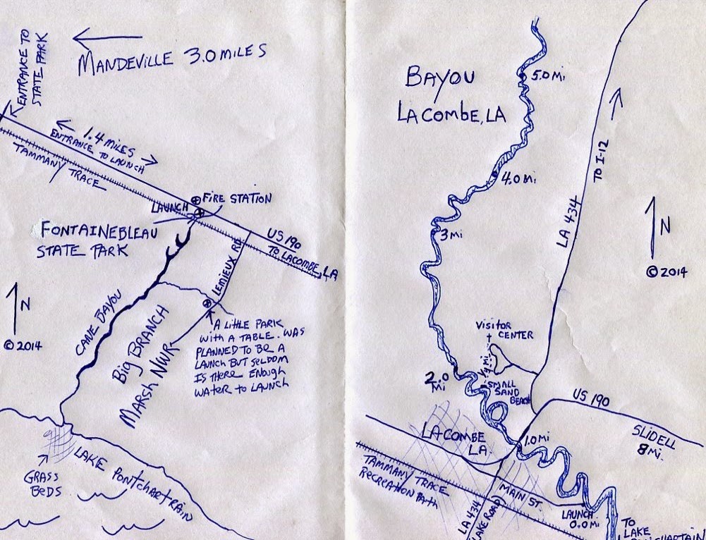
       Lunch into Bayou Cane, from the undeveloped boat launch off US.190.   Hard-packed sand and shell, the bank, slightly smaller than a basketball court, gradually slopes to the water.   From here it is  a two-mile trip to Lake Pontchartrain, almost a straight shot.  Bayou Cane is well known among locals and rare is the parking area empty of cars even on weekdays.  There are no facilities of any sort.
       The wetlands flanking the bayou are considered to be the last undeveloped large natural area on the north shore of Lake Pontchartrain.  But the paddle starts with a short stretch through forested, piney uplands.  A wooden RR trestle built for train traffic over a century ago, now is used by non-motorized recreational traffic on the Tammany Trace, a paved recreation path stretching 28 miles across St. Tammany Parish.
          Paddling toward the lake on the right bank is Fountainebleau State Park, on the left bank the 19,000 acre Big Branch Marsh National Wildlife Refuge.  On high ground to the left just past the RR bridge is a large brick house said to have once been the television studios of Cajun humorist, Justin Wilson.  Wilson, born in Tangipahoa Parish, was the star of a cooking show that appeared on public television for 30 years.  He died in 2001.
      Downstream from the bridge the bayou widens as paddlers leave the noise from busy US 190 astern.   Stay to the left at what appears to be a fork in the bayou just down stream of the bridge. About a mile downstream the trees suddenly stop and the scenery changes to marsh.  Thick stands of wire grass, and cane, some of it six to eight feet high grows from the silty black muck, crowding the banks.  Small sloughs and waterways cut paths through this tan and green curtain leading away from the bayou's distinct channel.  This is alligator habitat and the chances of seeing one or more of the fearsome reptile are very good, especially if the weather is warm.
       A diversity of habitats based on elevations that vary by just inches, populate the marsh.  In the spring and fall wild flowers bloom.  Fur bearers such as mink, otter, raccoon, muskrat, nutria rat and many other non-game species may be seen.
 
        In a tall solitary dead tree in a open area halfway between the lake and the launch, a large osprey nest rests.  Brown pelicans, the state bird, can be seen in winter.  The ridges and swamps on the north shore of Lake Pontchartrain offer one of the first significant landfall habitats for neotropical migratory birds after their trans-Gulf of Mexico migrations.
       Reaching the lake, if the wind in light or blowing off shore paddlers in canoes can venture into the open water and explore east and west along the lake's shore where a seemingly endless marsh grows right to the water's edge.  Go far enough in either direction and you might find a sliver of sandy beach on which to have a picnic lunch.  If the wind is from the south and creating a chop it is best to stay within the banks of Bayou Cane.
       Tahe shallow lake bottom t the entrance to Bayou Cane is covered by a large grass bed of eelgrass, wigeon grass and spike rush.   These fragile underwater grass beds provide a home for animal life while helping to purify the lake's waters.  The lake's shallow bottom tapers very, very gently away from the grassy north shore, the water in the lake only hip deep 50 yards from shore. 
       (Pollution in the lake is much less of an issue than it was 20 years ago when shell dredging in the lake kept the shallow waters constantly murky, smothering benthic flora and fauna.  Now, bacterial pollution from communities draining into the lake is the biggest risk to recreational users of the lake.)

Finding the boat launch

        The launch is adjacent to the south side of highway US 190 east of Mandeville.  There is no sign on the highway.   The speed limit on this stretch is 55 mph and you must slow considerably to make the right turn off the highway onto the sand, dirt and shell launch area.  The turn is about four-tenths of a mile east of the blinking yellow light at the main entrance to Fountainebleau S.P.  Your landmark is a fire station almost across the highway on the left (when driving east) from the right turn into the launch parking lot.  If you cross the bridge you have driver too far.
       What about paddling upstream of the launch going under the US190 bridge?  Well, shortly after loosing sight of the launch, a series of downed trees block progress up stream.

Bayou Lacombe

       Main St. in Lacombe deadends at the bayou Lacombe.  Here is a public boat launch used by paddlers.  There is a small area at the water with a grass and sand shore for launching canoes and kayaks.
     The bayou is broad here, at least 50 yards to the far bank. Kayak fisherman often launch here and head downstream to Lake Pontchartrain or look for deep fishing holes between the lake and the launch.  Redfish, speckled trout, largemouth bass, catfish and bream are among the fishes found in the bayou, USFWS brochures say.
        Paddlers with a mind for nature study and contemplation are encouraged to head upstream. The first two miles affords views of large wooded waterfront lots on high ground with manicured backyards sloping down to wooden decks where big boats are docked. Shortly after passing under the US 190 highway bridge the bayou becomes the western border of the headquarters of the Southeast Louisiana National Wildlife Refuges Bayou Lacombe Center and Visitor Center and Gardens, aka the Bayou Lacombe Center and the scenery becomes a bit wilder.
        Here the bayou winds and splits, flowing through a series oxbows and bottomland hardwood hummocks. You are out of sight of manmade structures for part of the journey, giving the small area the feeling of a remote wilderness despite being only yards away from suburban intrusions.  Have no worries about becoming lost here: all the waterways are short and eventually reconnect with the main channel.
       Less than a mile upriver of the US 190 bridge, look for the small sand beach (there is only one sand beach on the bayou) east off the bayou's main channel.  Pull up on the sand and take the quarter mile walk up to the refuge visitor center.  The USFWS bought the Holy Redeemer seminary campus a few years back, turning the former chapel into a visitor center featuring wildlife dioramas, interactive displays and exhibits exploring the wetland ecosystems and wildlife of the eight USFWS refuges administered from the Lacombe headquarters.  The museum is run by volunteers and is open Thursday-Saturday, 9:00 am to 4:00 pm.  There is a bookstore, gift shop and restrooms and a drink machine.  Admission is free.
       There are several self-guided hikes up to two miles on the walkways and trails of the USFWS campus.  Some pass through formal camellia gardens, native forests and wetland areas.  Bug repellent is recommended year around.  The trails are open Monday-Saturday, 7:00 am-4:00 pm.
       Once back in the boat, how far you paddle upstream from here depends a lot on your stamina.  The current is almost nil from the launch to the USFWS headquarters (unless it has rained heavily recently). But as the banks change from swampy muck to piney upland terra firma, the bayou becomes less bayou-like and more creek-like.  The downstream current gradually gains momentum.  About four miles upstream of the launch the current is not rippin' but even kayak paddlers will have to work their stroke to keep their forward speed up against the opposing flow. 
      Refuge property does not extend much up stream from the headquarters.  Yet long stretches of the bayou remains in a semi-wild state.  Homes and camps are built back from the bayou edge.  Intrusive housing stock is rare and most of the shore is a mix of pine uplands and bottomland hardwood hummocks reflecting into the mirror-still dark brown bayou.  Outside the USFWS holdings, and a couple of state and federal facilities barring public access, all the land is privately owned leaving no place to step out of a canoe or kayak.  Even so dense vegetation on the bank makes getting out of a kayak or canoe unscathed difficult.
       Paddlers will find plenty of water in the channel all the way to the I-12 highway bridge but the way might be blocked by fallen trees.
       Quite paddlers have a chance of seeing lots of bird life.  There are, of course alligators and lots of them if the weather is warm.  In summer banana spiders with bodies as big as ball point pens spin their webs across the waterway high above paddlers on the dark water's surface.  Summer also brings increased motorized boat traffic to the bayou but much of it is in a No Wake zone.   Locals claim the signs are enough to keep things civil.


For more information:
Southeast Louisiana National Wildlife Refuges Bayou Lacombe Center Visitor Center and Gardens, 61389 Highway 434, Lacombe, LA 70445.  Telephone 985/882-0093 or 985/882-2000.  On the web find them at www.fws.gov/bigbranchmarsh/

Paddling Through Time: How humans have interacted with and changed the land over time along Cane Bayou.  A canoe excursion on Bayou Cane led by the Friends of the Southeast Louisiana Refuges and held to raise money to buy more canoes and hire interpretative staff.  Registration is only by mail or in person when the visitor center is open.  You HAVE to preregister for each trip.  See calendar of events at the Big Branch Marsh web site for important details. Each paddler pays $10 and that includes the canoe, paddles and PFD.  You bring your own water, snacks, rain gear and bug repellent.  Trips begin at 9:00 am and last for two or three hours.  The trips are geared for adults but if you want to bring a kid, contact the Friends.  Don't just show up with a child.

For kayak rentals:
Bayou Adventure, 27725 Main St., Lacombe, LA. 70445, at Lake Rd. (LA 434)  Phone 985-882-9208.  Kayaks rent for $35.  Free delivery to Main St. boat launch in Lacombe.  Delivery charge to Cane Bayou is $10.  www.bayouadventures.com.
-30-


Wednesday, March 19, 2014

Paved rail/trail across AL/GA one of the longest in USA

The end of the Silver Comet Trail and the beginning of the Chief Ladiga Trail at the GA/AL state line. 
       The second longest paved trail in America (according to americantrails.org) is just an eight-hour drive, or less, from New Orleans.  The 33-mile Chief Ladiga Trail in Alabama and the 61.5 mile Silver Comet Trail in Georgia meet at the state line to form an unbroken paved path of 94.5 miles, perfect for long bicycle trips without ever having to share a roadway with a motorized traffic.
       The closest trail head to New Orleans is Anniston, AL.  (The trail ends right at the city's border with Weaver.  There are plans to take the trail into Anniston to the Amtrak station, about seven miles south of the trailhead.)
       In Georgia, milepost 0 is the Mavell Road Trailhead in Smyrna.
       Michael Tilley, 38, a bicyclist from Baton Rouge with 15-years of in-the-saddle experience rode the two trails end to end and back in the spring of 2013.  He took a leisurely approach taking four days to complete the ride averaging about 50 miles a day.  He stayed in motels along the way. The first section of the trail opened 20 years ago but is well maintained and mostly smooth, Tilley said.
     NOTE: CONSTRUCTION ON THE TRAIL IN COBB COUNTY GEORGIA, THE EASTERN-MOST GEORGIA COUNTY THROUGH WHICH THE TRAIL RUNS, WILL CLOSE SECTIONS OF THE PATH UNTIL SEPTEMBER OF 2014. THERE ARE NO DETOURS. BE SURE TO GET THE LATEST CONSTRUCTION INFO BEFORE MAKING THE DRIVE UP THERE TO DO THE RIDE. THERE APPEARS TO BE NO CONSTRUCTION PLANNED FOR THE CHIEF LADIGA TRAIL IN 2014.
       Talking trail with Tilley reminded me of my excursions to the trail several years ago.  Using several out-and-back day trips, I covered the trail from just south of Jacksonville, AL, east to the Powder Springs trailhead in Georgia, a total one-way distance of about 80 miles.
       Chief Ladiga Trail rolls north from Weaver, AL through a mix of farms, apartment houses and woods.  At Jacksonville the trail passes near the campus of Jacksonville State University, a major supporter of the trail.  Downtown Jacksonville (food, lodging) is about a half a mile east of the trail.
       This area was first settled before the Civil War but landmarks commemorating that history are hard to find.
       As you ride north from Piedmont the vista changes as riders approach the foothills of the Appalachian mountains in the distance.  The total gain in altitude from Anniston to the AL/GA line is only about 250 feet and any ups and downs on the trail are tamed by the trail's 2% grade.
       After Piedmont, the trail passes through the Talladega National Forest as it climbs gently beside Little Terrapin Creek to meet Georgia's Silver Comet Trail at Esom Hill at the state line.  The trail very gradually drops to Cedartown, GA.  This is a remote 24 miles so be sure to stock up with water and snacks before leaving either Piedmont or Cedartown to ride this section.         
       The trail follows the railroad grade through the highlands to spare riders from extreme climbs and descents with one exception: Cedartown and Rockmart.  Here the trail veers away from the railroad right of way forcing riders to negotiate steep climbs and hair raising downhills requiring excellent brakes.  One treacherous descent ends with a hard turn.
       The high point of the trail is in Georgia: EL 1092 near Dallas, GA.
       East of this, the trail returns to the fairly flat railroad grade for the trip east to Smyrna, GA, the eastern terminus of the trail.  Smyrna is part of the urban sprawl extending at least 25 miles north of Atlanta, and Tilley reports that the trail can get busy as it nears Smyrna and the Atlanta megaplex.
       (Getting to the trailheads near Smyrna from most anywhere in Atlanta can be time consuming because of the crowded highways connecting Smyra with Atlanta.  Allow plenty of time for this connection.)
       Flatlanders from Louisiana will enjoy riding through the Brushy Mountain Tunnel, 800 feet and 68 degrees all summer long.  Trailheads with restrooms, parking and picnic tables appear to be more numerous on the Georgia trail.
       The Rockport downtown has seen better days, and the trail passes through an iffy neighborhood in Cedartown so be sure to have a bike lock and park your bike where you can see it when off looking for a place to stay or somewhere to eat.
       Tilley said reserving rooms for motels along the route was easy.  But cyclists looking for a place to camp may have a harder time finding a place to stay.  In Alabama, call recreation centers in Piedmont and Jacksonville to see what camping is being offered to trail users.  There are no developed campgrounds in the Talladega NF near the trail put camping is permitted in most of the forest.  Chief Ladiga Trail cross the Pinhoti Trail but no bicycles are permitted on that trail.
       In Georgia riders will find a full-service private campground, "The Rock" a few miles east of Rockmart. The site also offers a primitive camping area and also some inexpensive primitive cabins. The private campground is ground zero for many concerts and large gatherings.  Be sure to check their schedule to avoid crowded conditions.  That is, unless someone you want to hear is performing.
       There is a primitive campground on the Silver Comet Trail that does not show on the map.  Good luck in finding out about that.
        You can learn more about hometown boy Sterling Holloway, a film star from back in the day, than you ever wanted to know at the restored railroad station, that also serves as the town's visitor center, on the trail at Cedartown.  There is a full service bicycle shop at the Powder Springs, GA trailhead that rents bicycles.  In Anniston try Wig's Wheels, 256-237-9447.
        Because Amtrak operates stations with baggage service in both Anniston and Atlanta it is tempting to want to use the train for a shuttle.  The train schedule is OK: leaves Anniston heading east to Atlanta late in the day.  The train station in Atlanta is downtown and just too far away from the Smyrna trailhead to make the shuttle practical.  But having to buy a box for your bike and taking the time to pack it, not counting the distance of the stations from the trailheads might encourage you to think twice about using Amtrak as a shuttle right now.
 
FOR MORE INORMATION:
www.silvercometga.com
www.chiefladigatrail.com
www.therockrvpark.com camping near Rockport, GA
www.piedmontcity.org or Jack Holder at the Eubanks Welcome Center in Piedmont, phone 256-447-3363.  You might be able to get a shuttle.
-30-