
The Tammany Trace is a 28-mile asphalt path crossing St. Tammany Parish (La) connecting the western city limits of Slidell in the east with downtown Covington in the west. The path mostly follows an abandoned railroad right of way purchased by the parish in December 1992.
The build-out began when eight miles of trail between Abita Springs and U.S. 190 at Mandeville was completed in the fall of 1994. As additional money became available, usually from federal grants, more sections were completed. In 2008 an existing railroad bridge over Bayou Lacombe was rebuilt as a bicycle/pedestrian bridge connecting east and west banks making the trail about 90 percent running from downtown Covington in the west to a dead end at Neslo Rd. west of Slidell, a distance of about 28 miles.
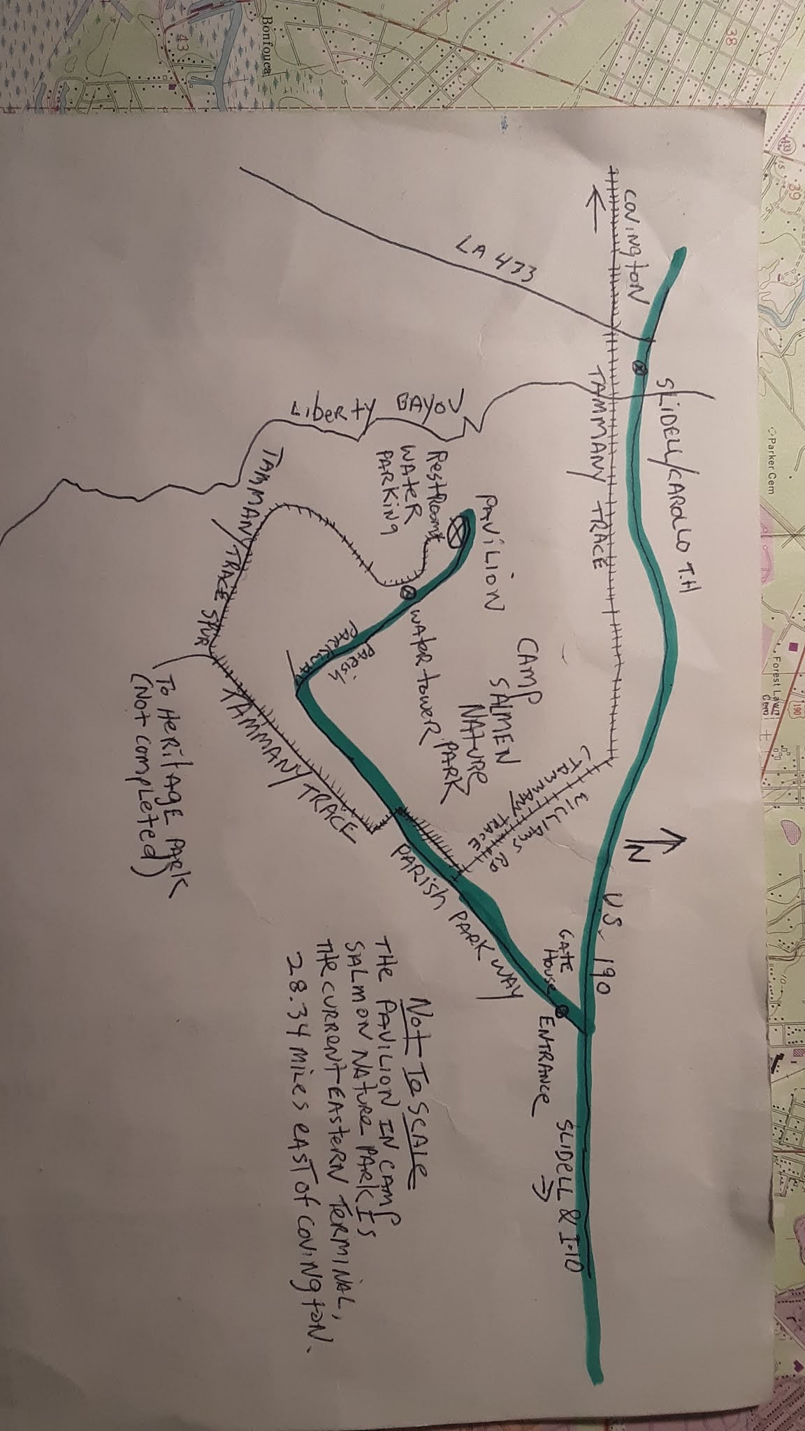
The opening of a 1.5 mile stretch of the asphalt path from Neslo Road to the Camp Salmen Nature Park in the fall of 2020 is seen by some trail users as completion of Louisiana's first and only rails to trails conversion.
But is it really complete? The answer is yes and no. The 1.5 mile extension linking Camp Salmen to the former Trace dead end at Neslo Rd. is more significant than the brevity of the addition might suggest. Now there is a destination at the eastern end of the Trace that can be accessed by cyclists and hikers without having to mix with motorized traffic; Camp Salmen. The130-acre nature preserve with a playground, four hiking trails through piney forests and bottomland hard woods and a relaxing vista on the banks of Bayou Liberty is worthy of a visit. Entree to the park is free.
There are many attractions on or near the western stretch of the trail, restaurants, a high-end shopping district in Covington, at least one brew pub in Abita Springs, museums in Abita Springs and Lacombe and a state park (Fountainebleau), just to mention a few.
Now with Camp Salmen Nature Park anchoring the eastern end of the Trace and featuring an innovative playground accommodating special needs children who can play and interact with other children with or without special needs, a pavilion with parking, drinking water, rest rooms and numerous tables and benches for people watching and picnics non-motorized Trace users have a reason a reason to expend the extra energy to ride more of the popular linear trail.
( Marauading vandals invading the remote park at night have forced the removal of drink and snack machines at the pavilion, park officials say.)
But parish officials promised 31 miles of paved trail almost 30 years ago when the railroad R.O.W was purchased. So how can it be considered finished when "only" 28.35 miles are paved now, about 90 percent of the total distance possible? Where are the approximately 3.5 miles users are due?"
Trying to complete the eastern portions of the Trace presented parish officials with problems they did not anticipate 30 odd years ago. The original R.O.W. crosses highway U.S. 190 at grade level. The tremendous increase in highway traffic the parish has experienced in the last 30 years, having the Trace cross the busy highway at grade level is too dangerous to consider. To protect Trace users from the thundering traffic near Mandeville a tunnel had to be built under U.S. 190 there. A second tunnel is now being built where LA 59 crosses the Trace at grade level between Abita Springs and Mandeville and may open soon.
Running the Trace south of U.S. 190 presented its own problems. From the beginning construction of the western end of the Trace, from Covington through Abita Springs, Mandeville and Lacombe, went pretty much as promised: rails and ties were removed and where trains once ran beginning in the 19th century, bicyclists, runners, walkers, skaters now make their way through the woods and neighborhoods of the southern part of the parish on a broad asphalt path crossing 31 bridges.
But getting the trail the last few miles into Heritage Park in downtown Slidell existing streets will have to be used; there is no off-street R.O.W between Camp Salmen and Heritage Park for a trail to be built. Any bike path will have to utilize existing streets through crowded suburban neighborhoods. Most are narrow streets with no shoulders and often flanked by deep drainage canals. How narrow? Until recently mail boxes on one street were mounted parallel to the street to lessen the chance they would be knocked down by passing traffic.
The official position of parish officials is that Heritage Park will be the eastern terminus of the Tammany Trace and some maps show Camp Salmen connecting with Heritage Park. But right now most parish officials are calling the extension "a long-term goal."
Bicycle riders and walkers heading east on the Trace from the Slidell/Carollo TH can just blow-through the former dead end at Neslo Rd. The Trace passes a busy U.S. 190, (wooden bollards protect Trace users) then on to a straight section of Williams Rd. Enter the park at Parish Parkway, the only vehicular access in and out of the park--motorized traffic enters the park at U.S. 190. Follow the signs as the Trace parallels the parkway. Near the southeast corner of the park the paved path will fork. The path east goes out of the park and is part of the future connection with Heritage Park. The paving west is the Tammany Trace Spur which leads to the pavilion with the water, bathrooms and parking and may be signed as such. If beginning your Trace ride from Camp Salmen, leave the main pavilion keeping the water tower straight ahead.
TRAIL NOTES: The Slidell/Carollo trail head is close to Slidell but not IN Slidell. There is a large parking lot there and restrooms, water and a drink machine, It sits next to a convenience store. No pets are allowed on the Tammany Trace. No motorized vehicles.
A section of the Trace, about 560 feet, under the I-12 overpass is closed. The Interstate 12 overpass is being widened. And it will be closed for at least six more months. It is really closed. There is no detour. You cannot connect the north and south sections. Do not try. Riding south from Abita Springs the path is closed just past the Koop Rd. Trace Headquarters (the green caboose)). Heading north from Mandeville the Trace is closed at Little Creek Bridge.
The construction on the overpass may be progressing to a point that the Trace may be briefly opened for a few weeks to a few months this summer (2021) and then closed again but this unconfirmed speculation (maybe a measure of wishful thinking, too) by a Trace official recently.
Construction is ongoing on the tunnel bringing the Trace under LA 59 between Abita Springs and Koop Road. The Trace is not closed at the tunnel construction site; Trace traffic is detoured around the tunnel construction. When the tunnel is open to Trace users it will eliminate one of the more interesting and dangerous games of chicken Trace users have had to play when crossing the heavily traveled highway at grade level for the past 25 years.
-30-
No comments:
Post a Comment