 |
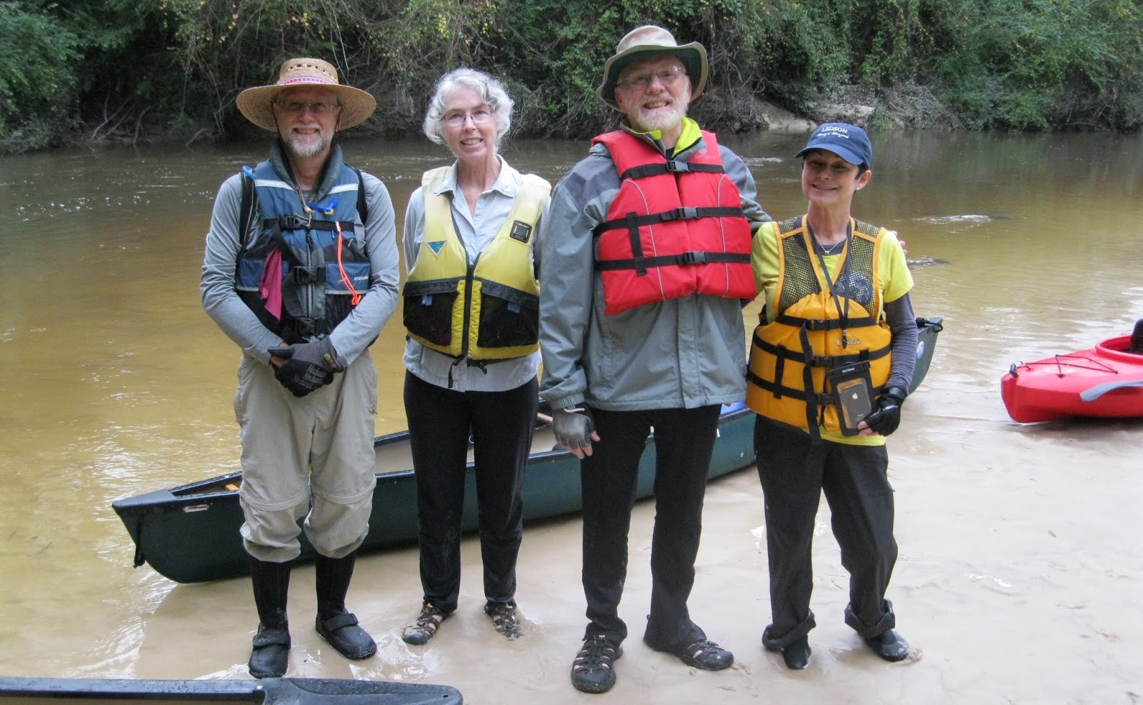
Bayou Haystackers Paddling Club members pose on a Bogue Falaya River sandbar just upstream from the Lee Rd. (LA 437) bridge, November 22, 2015. A group of five paddled upstream from the Columbia St. Landing in Covington to the bar. From left are Dirk Van Duym of Covington and the leader of the group; Evelyn Almquist, Metairie; Pierre Sargent, Baton Rouge and Gina DiVincent, Metairie. The USGS gauge at the Boston St. bridge in Covington was reading 2.02 feet when the picture was taken.
|
For 28 miles the Bogue Falaya River flows in a southwesterly direction from the piney woods of Washington Parish to its juncture with the Tchefuncte River south of downtown Covington, LA. Shallow and creek-like until it gets to Covington (LA), it flows the color of caramel, taking the tint from the tannin that leaches into the stream from the decaying vegetation at its banks.
At Covington, the Bogue Falaya a tributary to the Tchefuncte River which flows into Lake Pontchartrain, was deep enough to become a 19th century river of commerce. Beginning with the founding of Covington in the early 1800s, the landing at the end of Columbia St. was busy with freight and passengers carried by small steamboats and shallow draft sailing schooners traveling to and from New Orleans.
The vibrant and noisy wharves are gone now, replaced by a quiet park. In modern times hubbub on the river most likely comes from recreational use. Palatial homes built on high ground along the river's waterfront, many with docks and boat houses, are home to a wide variety of speedboats, ski boats and personal watercraft. The waterway buzzes with motorboat traffic when the weather is nice.
When the Louisiana Natural and Scenic Streams system was created by the state legislature in 1970--one of the nation's first--the Bogue Falaya River was not included. When amended into the system later only the portion of the river--from the LA 437 bridge north of Covington to the river's headwaters in Washington Parish--was included in the act's protections.
A canoe trip is planned
Except for those living in its immediate vicinity, the Bogue Falaya is not a favorite among paddlers. Access to the stream is difficult. The only two public access points for paddlers are below the Boston St. Bridge in Covington where motorboat traffic is common. There is no public access on the upper Bogue Falaya upstream of the Lee Rd. bridge where the river is like a creek, winding and shaded by leafy tree canopies and too shallow for the motorboats to go.Dirk Van Duym loves to canoe. Born into a canoeing family, the Covington architect has spent his spare time in the years since exploring the streams and bayous of Southeast Louisiana and beyond, sometimes confidently going by himself, at other times in the company of like-minded adventurers. On these trips he is almost always paddling his sleek lightweight, cream-white, handmade in New York state, solo canoe.
Early in November, Van Duym had an urge to go canoeing on the Bogue Falaya River, a stream he paddles occasionally because of its convenience. (Van Duym's favorite canoeing venue in the parish is Cane Bayou.) Portions of the river in Covington are on track to be mapped and signed creating the parish's first "blueway" or paddle trail and some time had passed since the veteran paddler last explored it. He especially wanted a fresh impression of the stretch between the Bogue Falaya Park upstream to the Lee Rd. (LA 437) bridge, a stretch of the historic waterway less likely to be invaded by speeding powerboats. This stretch of the river is not included in the Louisiana Natural and Scenic Streams System.
A member of the Bayou Haystackers Paddling Club, (BHPC) Van Duym posted notice of his upcoming trip on the BHPC calendar. He described a trip that differed slightly from standard BHPC outings: It was billed as a "social trip." And paddlers would be going upstream working against a current for half of the trip. (The trip was out and back.)
While all BHPC trips are, at their core "social," trips, some trips require more skill, stamina and specialized gear than others. Leaders carefully rate the difficulty of the trips they lead. Ratings are based on the distance to be paddled and the required skill and experience needed to control a canoe or kayak in the expected conditions. Paddlers are expected to choose trips within their ability.
In BHPC Speak "social" means a benign trip where everyone is welcome, even tyros in borrowed boats with only a passing interest in paddling. No one is left behind. Gear or paddling skill are not issues. Just be sure to wear a life jacket. And if not a BHPC member bring five dollars to cover insurance.
Van Duym's outing plans even included docking at a riverfront restaurant for a late lunch before taking out. The trip was expected to take about four hours at most.
Paddling upstream is commonly thought of as going the wrong way, even by experienced paddlers. Because most paddling trips are on creeks and rivers with currents too strong to overcome when paddling against them (even a sluggish flow of just one mile an hour can require significant effort to overcome) paddlers have to resort to tedious vehicle shuttles to complete most paddle trips on moving water. The necessity for a vehicle shuttle is eliminated when, after paddling upstream, boaters turn around and follow the current back to the put-in.
To explore this stretch of the Bogue Falaya, paddling upstream is the only option unless permission from a landowner fronting the river can be secured prior to launching. There are no public access points upstream of the Columbia St. landing.
Van Duym's goal for the group was to paddle upstream about two miles to the Lee Rd. (LA 437) bridge then float back to the restaurant. This objective was not set in concrete: If at any point the current became too strong to master easily, the group would turn around, Van Duym promised. But Van Duym found the Bogue Falaya's current to be tame enough for upstream paddling on two previous trips so the chances were good the group could make it.
The seven-day weather forecast ahead of the trip could not have been more inviting: blue skies and cool temperatures. A prediction of rain earlier in the week did not appear to be much of a problem. Nine paddlers expressed interest via email.
But as the trip drew closer the forecast for Saturday suddenly darkened to grey clouds with light rain followed by the coldest temperatures since March. Surprisingly, the mid-week rain, raised the water level significantly, quickening the current considerably, bringing the chocolate brown, silt-laden river to the edge of its banks.
Paddlers contemplating an upstream paddle on the Bogue Falaya should look for a water level of 1.75 feet or below at the USGS gauge on the Boston St. bridge in Covington to have at least a fighting chance of making it upstream to the Lee Rd. bridge. Water levels higher than 2.30 can create currents of two miles per hour or more, too fast for even a strong paddler to overcome for long. A couple of days before the BHPC trip the water level of the river was about five feet.
After the rain stopped, and the sun came out Van Duym emailed frequently about the slowly falling water levels. A "Plan B" was proposed. The trip roster shrank.
.
 |
Evelyn Almquist heads downstream on the Bogue Falaya River north of Covington, LA., Nov. 21, 2015. She was part of a group of five members of the Bayou Haystackers Paddling Club exploring the river, on tap to be included in the first blueway or paddle trail planned for St. Tammany Parish, the Three Rivers Paddling Trail.
|
Launching into history
Before the Civil War, timber, naval stores, bricks, cotton, cattle and produce from land-locked forests and farms as far away as Mississippi and Alabama were hauled by wagon to the Columbia Street Landing for shipment across Lake Pontchartrain to New Orleans and markets beyond.But after the Civil War, (town officials voted to remain loyal to the Union but sympathies of the townspeople were with the new Confederate nation), hard times came to Covington. A rapidly expanding network of railroads began providing both a cheaper and quicker alternative to shipping by water. But there was no railroad to Covington. Business from moving freight on the Bogue Falaya River dried up.
Finally, in the late 1880s a spur railroad from Slidell reached Covington connecting the town with New Orleans. The northshore, long known for its healthful pine-scented environment and mineral springs, now boomed with tourism. The train trip from New Orleans to Covington took only two and a half hours, each way. People began to commute. Pictures taken about the turn of the 20th century show sailing schooners and steam packets competing for space at the landing.
The wharves and bustling commerce they enabled are long gone. A plaque and a small, quiet park, often used for low-key outdoor concerts, commemorate those commercial heydays of the last century. The bare clay stevedores trod toting bales of cotton a century or more ago is now a lush green and groomed lawn surrounded by tall trees. A nice place for a picnic.
Five paddlers, two using kayaks and three in solo canoes, gathered at 10 a.m. at the landing and prepared to launch. The group would launch under an oppressive grey sky that looked like it could pour rain at any minute, just the opposite of what was forecast a week ago. On the other hand, temperatures were mild and there was no wind.
River levels at the Boston St. bridge gauge had fallen significantly, the still murky river measuring 2.27 feet. About a foot higher than the last time he made the trip but still low enough to make an attempt, Van Duym said. The trip was on.
At this water level there was no sandy beach exposed at the landing. The grass and clay bank met the water directly and was as slick as melted butter. Trying to avoid an embarrassing and drenching capsize, paddlers briefly became comedic contortionists to get situated in their tippy craft. Safely away from shore everyone dug their paddles into the brown water and settled into the rhythm of the trip. Next stop- Lee Rd. bridge!
Are we there yet?
Passing under the Boston St. bridge, the high US 190 bridge a few yards upstream and under some power lines the group made good headway. Here the river is about 30 feet wide and almost free of stumps and blow downs. (Which is a mystery as post cards from the late 1890's show Gilded Age ladies in long dresses shaded by frilly parasols canoeing a Bogue Falaya River clogged with much more debris than in it now.)Very few structures are visible from the river, a couple of houses maybe, most of them well back from the water. Here the river flows by the muddy banks of a flood plain. A dense covering of squat, woody shrubbery grows down to the water's edge and there is a smattering of pine trees. This stretch of the river has an open feeling, the faint smell of the mud, the river and the surrounding flood plain hung in the still air.
It was only a hundred years ago that the last of the easy to reach, slow growing hardwoods and tall, old growth pine trees growing here were harvested and cut into lumber, sent by water and rail to shipyards in nearby Madisonville or to New Orleans to become homes.
Vegetation hugging the banks is still green, lush. Fall is a fleeting and brief season in this part of Louisiana and it really has not been cold enough long enough to kill anything yet. When this trip was made there had not even been a night of frost on the northshore. There was a light frost a few days later.
Evidence of a current began about where the Little Bogue Falaya comes in from river left. When flowing past stumps and sticks paddlers noticed the river's otherwise smooth surface now wrinkled into little "Vs" pointing upstream. It became more of an effort to maintain headway and keep parallel with the current against the quickening flow. Losing headway against a current means a boat can be swept sideways quickly and pushed downstream. If swept into a stump or blow down before a paddler can regain control the water piles up against the upstream side of the pinned boat swamping it. An unsuspecting paddler can be dumped in seconds.
As the group nears highway 437 the scenery begins to transition from bottomland hardwood forest to upland pine. As a result the small river becomes more like a large creek. Paddlers are now churning a translucent stream the color of strong, sweet tea, squeezed between steep, dark loamy banks with more trees, less undergrowth. Some taller trees grow at an angle, nearly meeting, their crowns forming a leafy canopy over a quickening but quiet stream. It is pretty here.
But the paddlers are too busy paddling for sight-seeing. Paddling against an ever stronger current, hearing the traffic noise from the highway at their goal motivates the tired boaters to stroke harder. At the bridge paddlers flail against the stiff current struggling to pass under the narrow concrete span. Once upstream Van Duym directs the group to a slack-water pool and sandbar--the first sandbar they have seen since leaving the muddy slippery launch in downtown Covington.
Despite the tenacious grey skies the gloomy weather seems to brighten a bit as paddlers step out of their boats onto the coarse tan sand to stretch and rest. They made it.
Standing on the narrow sandbar, Van Duym made a big reveal. Up by the road and out of sight, was the lot where the first house he designed once stood. Viewing Google Earth on his computer he saw that the house must have burned to the ground recently, leaving only a charred scar, he said.
The group, having attained their goal, was anxious to head back. After a brief rest they slid their boats back into the water happy to be hurried downstream by the current, now in their favor. Somewhere near the Little Bogue Falaya, the group passed two boys fishing, one in a kayak-- the only people the group saw during their time on the river. The boys said that the river can be busy with kayak traffic on weekends if the weather is nice.
Several times a light drizzle would prompt the paddlers to don rain gear only to have to take it off a few minutes later when the rain stopped.
With the current in their favor the five slightly damp paddlers made it to the restaurant dock in about an hour. On the restaurant's back deck, chilled but pleased with their accomplishment, the quintet warmed to a repast of seafood and red beans and rice washed down with cups of hot decaf coffee before launching again for the quick paddle back to Columbia St. Landing and the drive home.
Sources;
"Covington" by David Arbo, 2011. A book in the "Images of America" series published by Arcadia Publishing, Charleston, South Carolina.
Note:
The plan was to launch from the Bogue Falaya Park but a festival in the park closed it to paddlers. The put-in was moved outside park boundaries a few dozen yards upstream of the Columbia St. Landing. Neither access is particularly accommodating to paddlers launching a canoe or kayak so one is as good as another for a put-in. Both are free. Check the Bogue Falaya Park website for hours of operation. Parking at the park and the landing might seem like a long way from the water if you are carrying a heavy boat so you might want to bring a folding, two-wheel boat caddy.
-30-
1 comment:
Excellent write-up, Jack. Thanks!
Post a Comment