Showing posts with label Paddle trip. Show all posts

Friday, December 11, 2015

Fall color on Bayou Lacombe (LA)

Paddlers admire a bit of fall color on the banks of Bayou Lacombe in late November 2015
 
         A late November canoe trip on Bayou Lacombe revealed a colorful surprise.  On the banks near the water, amid a green forest of pines and broadleaf evergreens, grew several red maples, widely spaced, dotted with bright scarlet leaves, as if hung on the tree like Christmas ornaments.
          Scenes of fall color such as this, a solitary tree or two, their leaves aflame with the bright colors of fall, are not uncommon in southeast Louisiana.  But sometimes it is a surprise to see them.  Colorful fall displays of bright reds, oranges and yellow leaves are more commonly associated with colder climates and rolling hills than with warm and flat southeast Louisiana.  Here, most deciduous trees--those trees that lose their leaves at the end of the growing season--produce leaves that just turn brown and fall.
          The balmy late November day the paddlers were on Bayou Lacombe revealed a smattering of colorful exceptions.  The group launched at the Main St. boat launch in "downtown" Lacombe and were about a mile and a half upstream, at the edge of the Big Branch Marsh NWR when red and yellow leaves were was first noticed floating on the surface of the dark stream.
           "The red leaves were most probably from the red maples, one of the few native trees to produce the bright red you saw," refuge manager Daniel Breaux said later in a telephone interview.  "Or they could have come from the Chinese Tallow tree, an invasive tree species with leaves that turn red or yellow this time of year."
         The soil determines where a tree grows.  The torpid bayou is flanked mostly by pine flat woods; sandy soil, well drained and elevated, a favorite soil for growing pine trees. But deciduous trees prefer a more moist soil to grow in.  This is why fall color in the trees in southeast Louisiana is most likely to be found in swampy wetlands, bottomland hardwood forests and near the banks of streams and bayous such as Bayou Lacombe.
        Other trees along the Gulf Coast also signal the season is changing.  The star-shaped sweetgum leaf can turn red or yellow in autumn.  The American elm, a tree that can grow as tall as a ten-story building. can produce bright yellow leaves in autumn.
          The American Holly is often seen in northshore forests.  Its bright green leaves and deep red berries are popular additions to holiday decorations and table centerpieces.
          Evergreen trees have green leaves year around, hence the name "evergreen".  Most evergreens here are pines, their leaves are needle shaped.  But a few evergreen trees here have broad flat leaves which stay green through the fall and winter.  Live oak trees and southern magnolia trees are two of the best known examples of broadleaf evergreens down South.
          The opposite is also true.  Baldcypress trees have needle leaves but the tree is not an evergreen; each fall their needles turn a rust color and drop leaving the baldcypress branches bare.  A pine tree with brown needles is thought to be dying and it probably is.  But a baldcypress, its branches covered with brown needles that are soon to be shed leaving bare branches is just going through its life cycle and will grow new bright green needles in spring.

Sources:
Fountainebleau State Park Nature Trail Guide, revised by Rita McMurray, park naturalist, Fountainebleau State Park, Mandeville, LA., 12/99.

More Info:
Rent a kayak from Bayou Adventure, 985-882-2908, to explore the bayou yourself.  The business, which also caters to fishermen, will deliver and pick up your rented kayak from the Main St. launch for no additional charge.
While paddling the bayou, take time to come ashore at the headquarters facility for the Southeast Louisiana National Wildlife Refuges Complex.  From the 110 acre site, eight refuges in southeast Louisiana are managed.  There is also a visitor center in a building that was once a chapel.  Inside is a wonderful museum with dioramas and interactive displays.  There is a gift shop too.  Paddle about a mile and a half upstream of the Main St. launch, look on river left for a mowed lawn sloping down to a narrow sand beach and dock.  Beach is hidden by hardwood hammocks so poke around to find it.   There is no sign.  Walk up the rise and continue past the law enforcement office about a quarter of a mile on a blacktop road to the visitor center.  Volunteers operate the museum and gift shop so call 985-882-2000 for hours and days of operation.
 -30-  

Wednesday, November 25, 2015

Bogue Falaya: Bogue Falaya Park to Lee Rd. Bridge (LA 437)

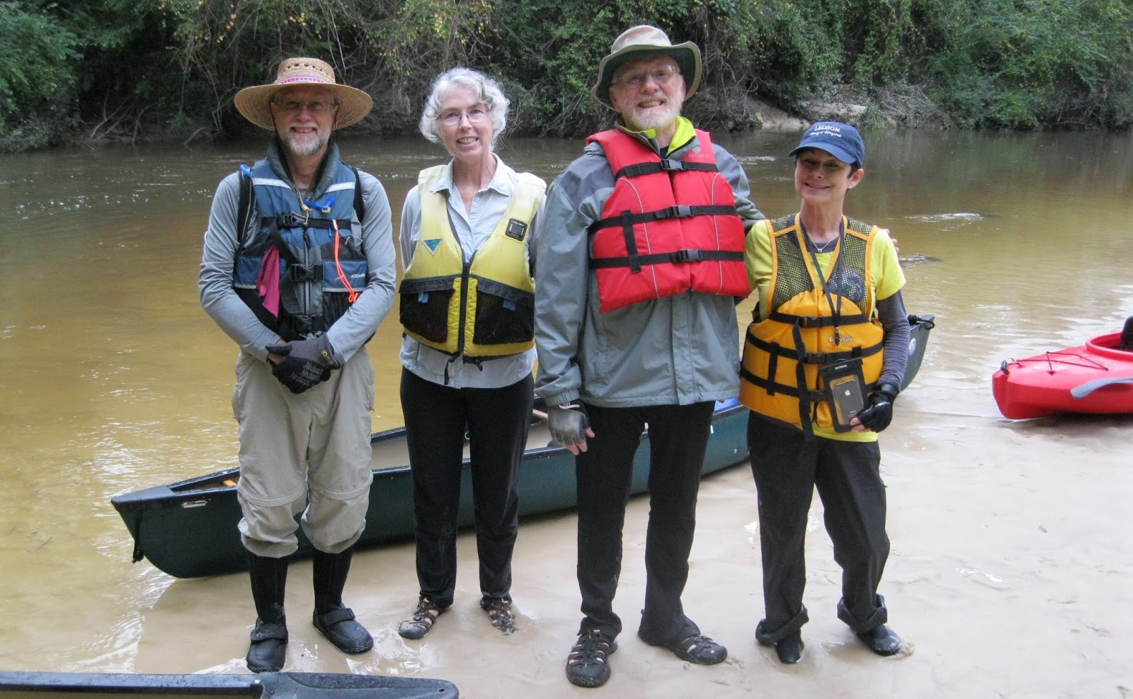
 Bayou Haystackers Paddling Club members pose on a Bogue Falaya River sandbar just upstream from the Lee Rd. (LA 437) bridge, November 22, 2015.  A group of five paddled upstream from the Columbia St. Landing in Covington to the bar.  From left are Dirk Van Duym of Covington and the leader of the group; Evelyn Almquist, Metairie; Pierre Sargent, Baton Rouge and Gina DiVincent, Metairie.  The USGS gauge at the Boston St. bridge in Covington was reading 2.02 feet when the picture was taken. 

       For 28 miles the Bogue Falaya River flows in a southwesterly direction from the piney woods of Washington Parish to its juncture with the Tchefuncte River south of downtown Covington, LA.  Shallow and creek-like until it gets to Covington (LA), it flows the color of caramel, taking the tint from the tannin that leaches into the stream from the decaying vegetation at its banks.
        At Covington, the Bogue Falaya a tributary to the Tchefuncte River which flows into Lake Pontchartrain, was deep enough to become a 19th century river of commerce.  Beginning with the founding of Covington in the early 1800s, the landing at the end of Columbia St. was busy with freight and passengers carried by small steamboats and shallow draft sailing schooners traveling to and from New Orleans.
          The vibrant and noisy wharves are gone now, replaced by a quiet park.  In modern times hubbub on the river most likely comes from recreational use.   Palatial homes built on high ground along the river's waterfront, many with docks and boat houses, are home to a wide variety of speedboats, ski boats and personal watercraft.  The waterway buzzes with motorboat traffic when the weather is nice.
            When the Louisiana Natural and Scenic Streams system was created by the state legislature in 1970--one of the nation's first--the Bogue Falaya River was not included.  When amended into the system later only the portion of the river--from the LA 437 bridge north of Covington to the river's headwaters in Washington Parish--was included in the act's protections.

A canoe trip is planned

           Except for those living in its immediate vicinity, the Bogue Falaya is not a favorite among paddlers.  Access to the stream is difficult.  The only two public access points for paddlers are below the Boston St. Bridge in Covington where motorboat traffic is common.  There is no public access on the upper Bogue Falaya upstream of the Lee Rd. bridge where the river is like a creek, winding and shaded by leafy tree canopies and too shallow for the motorboats to go.
          Dirk Van Duym loves to canoe.  Born into a canoeing family, the Covington architect has spent his spare time in the years since exploring the streams and bayous of Southeast Louisiana and beyond, sometimes confidently going by himself, at other times in the company of like-minded adventurers.  On these trips he is almost always paddling his sleek lightweight, cream-white, handmade in New York state, solo canoe.
        Early in November, Van Duym had an urge to go canoeing on the Bogue Falaya River, a stream he paddles occasionally because of its convenience.  (Van Duym's favorite canoeing venue in the parish is Cane Bayou.)  Portions of the river in Covington are on track to be mapped and signed creating the parish's first "blueway" or paddle trail and some time had passed since the veteran paddler last explored it.   He especially wanted a fresh impression of the stretch between the Bogue Falaya Park upstream to the Lee Rd. (LA 437) bridge, a stretch of the historic waterway less likely to be invaded by speeding powerboats.  This stretch of the river is not included in the Louisiana Natural and Scenic Streams System.
          A member of the Bayou Haystackers Paddling Club, (BHPC) Van Duym posted notice of his upcoming trip on the BHPC calendar.  He described a trip that differed slightly from standard BHPC outings:  It was billed as a "social trip."   And paddlers would be going upstream working against a current for half of the trip.  (The trip was out and back.)
        While all BHPC trips are, at their core "social," trips, some trips require more skill, stamina and specialized gear than others.  Leaders carefully rate the difficulty of the trips they lead.   Ratings are based on the distance to be paddled and the required skill and experience needed to control a canoe or kayak in the expected conditions.  Paddlers are expected to choose trips within their ability.
        In BHPC Speak "social" means a benign trip where everyone is welcome, even tyros in borrowed boats with only a passing interest in paddling.  No one is left behind.  Gear or paddling skill are not issues.  Just be sure to wear a life jacket.  And if not a BHPC member bring five dollars to cover insurance.
        Van Duym's outing plans even included docking at a riverfront restaurant for a late lunch before taking out.  The trip was expected to take about four hours at most.
         Paddling upstream is commonly thought of as going the wrong way, even by experienced paddlers.  Because most paddling trips are on creeks and rivers with currents too strong to overcome when paddling against them (even a sluggish flow of just one mile an hour can require significant effort to overcome) paddlers have to resort to tedious vehicle shuttles to complete most paddle trips on moving water.  The necessity for a vehicle shuttle is eliminated when, after paddling upstream, boaters turn around and follow the current back to the put-in.
         To explore this stretch of the Bogue Falaya, paddling upstream is the only option unless permission from a landowner fronting the river can be secured prior to launching.  There are no public access points upstream of the Columbia St. landing.
          Van Duym's goal for the group was to paddle upstream about two miles to the Lee Rd. (LA 437) bridge then float back to the restaurant.  This objective was not set in concrete:  If at any point the current became too strong to master easily, the group would turn around, Van Duym promised.  But Van Duym found the Bogue Falaya's current to be tame enough for upstream paddling on two previous trips so the chances were good the group could make it.
          The seven-day weather forecast ahead of the trip could not have been more inviting: blue skies and cool temperatures.  A prediction of rain earlier in the week did not appear to be much of a problem.  Nine paddlers expressed interest via email.
           But as the trip drew closer the forecast for Saturday suddenly darkened to grey clouds with light rain followed by the coldest temperatures since March.  Surprisingly, the mid-week rain, raised the water level significantly, quickening the current considerably, bringing the chocolate brown, silt-laden river to the edge of its banks.
           Paddlers contemplating an upstream paddle on the Bogue Falaya should look for a water level of 1.75 feet or below at  the USGS gauge on the Boston St. bridge in Covington to have at least a fighting chance of making it upstream to the Lee Rd. bridge. Water levels higher than 2.30 can create currents of two miles per hour or more, too fast for even a strong paddler to overcome for long.  A couple of days before the BHPC trip the water level of the river was about five feet.
         After the rain stopped, and the sun came out Van Duym emailed frequently about the slowly falling water levels.  A "Plan B" was proposed.  The trip roster shrank.
          .

Evelyn Almquist heads downstream on the Bogue Falaya River north of Covington, LA., Nov. 21, 2015.  She was part of a group of five members of the Bayou Haystackers Paddling Club exploring the river, on tap to be included in the first blueway or paddle trail planned for St. Tammany Parish, the Three Rivers Paddling Trail.
 

Launching into history   

      Before the Civil War, timber, naval stores, bricks, cotton, cattle and produce from land-locked forests and farms as far away as Mississippi and Alabama were hauled by wagon to the Columbia Street Landing for shipment across Lake Pontchartrain to New Orleans and markets beyond.
        But after the Civil War, (town officials voted to remain loyal to the Union but sympathies of the townspeople were with the new Confederate nation), hard times came to Covington.  A rapidly expanding network of railroads began providing both a cheaper and quicker alternative to shipping by water.  But there was no railroad to Covington.  Business from moving freight on the Bogue Falaya River dried up.
        Finally, in the late 1880s a spur railroad from Slidell reached Covington connecting the town with New Orleans.  The northshore, long known for its healthful pine-scented environment and mineral springs, now boomed with tourism.  The train trip from New Orleans to Covington took only two and a half hours, each way.  People began to commute.  Pictures taken about the turn of the 20th century show sailing schooners and steam packets competing for space at the landing.
        The wharves and bustling commerce they enabled are long gone.   A plaque and a small, quiet park, often used for low-key outdoor concerts, commemorate those commercial heydays of the last century.  The bare clay stevedores trod toting bales of cotton a century or more ago is now a lush green and groomed lawn surrounded by tall trees.  A nice place for a picnic.
          Five paddlers, two using kayaks and three in solo canoes, gathered at 10 a.m. at the landing and prepared to launch.  The group would launch under an oppressive grey sky that looked like it could pour rain at any minute, just the opposite of what was forecast a week ago.  On the other hand, temperatures were mild and there was no wind.
          River levels at the Boston St. bridge gauge had fallen significantly, the still murky river measuring 2.27 feet.  About a foot higher than the last time he made the trip but still low enough to make an attempt, Van Duym said.  The trip was on.
             At this water level there was no sandy beach exposed at the landing.  The grass and clay bank met the water directly and was as slick as melted butter.  Trying to avoid an embarrassing and drenching capsize, paddlers briefly became comedic contortionists to get situated in their tippy craft.  Safely away from shore everyone dug their paddles into the brown water and settled into the rhythm of the trip.  Next stop- Lee Rd. bridge!

Are we there yet?

         Passing under the Boston St. bridge, the high US 190 bridge a few yards upstream and under some power lines the group made good headway.  Here the river is about 30 feet wide and almost free of stumps and blow downs.  (Which is a mystery as post cards from the late 1890's show Gilded Age ladies in long dresses shaded by frilly parasols canoeing a Bogue Falaya River clogged with much more debris than in it now.)
          Very few structures are visible from the river, a couple of houses maybe, most of them well back from the water.  Here the river flows by the muddy banks of a flood plain.  A dense covering of squat, woody shrubbery grows down to the water's edge and there is a smattering of pine trees.  This stretch of the river has an open feeling, the faint smell of the mud, the river and the surrounding flood plain hung in the still air.
         It was only a hundred years ago that the last of the easy to reach, slow growing hardwoods and tall, old growth pine trees growing here were harvested and cut into lumber, sent by water and rail to shipyards in nearby Madisonville or to New Orleans to become homes.
          Vegetation hugging the banks is still green, lush.  Fall is a fleeting and brief season in this part of Louisiana and it really has not been cold enough long enough to kill anything yet.  When this trip was made there had not even been a night of frost on the northshore.  There was a light frost a few days later.
         Evidence of a current began about where the Little Bogue Falaya comes in from river left.  When flowing past stumps and sticks paddlers noticed the river's otherwise smooth surface now wrinkled into little "Vs" pointing upstream.  It became more of an effort to maintain headway and keep parallel with the current against the quickening flow.  Losing headway against a current means a boat can be swept sideways quickly and pushed downstream.  If swept into a stump or blow down before a paddler can regain control the water piles up against the upstream side of the pinned boat swamping it.  An unsuspecting paddler can be dumped in seconds.
          As the group nears highway 437 the scenery begins to transition from bottomland hardwood forest to upland pine.  As a result the small river becomes more like a large creek.   Paddlers are now churning a translucent stream the color of strong, sweet tea, squeezed between steep, dark loamy banks with more trees, less undergrowth.  Some taller trees grow at an angle, nearly meeting, their crowns forming a leafy canopy over a quickening but quiet stream.  It is pretty here.
         But the paddlers are too busy paddling for sight-seeing.   Paddling against an ever stronger current, hearing the traffic noise from the highway at their goal motivates the tired boaters to stroke harder.  At the bridge paddlers flail against the stiff current struggling to pass under the narrow concrete span.  Once upstream Van Duym directs the group to a slack-water pool and sandbar--the first sandbar they have seen since leaving the muddy slippery launch in downtown Covington.
          Despite the tenacious grey skies the gloomy weather seems to brighten a bit as paddlers step out of their boats onto the coarse tan sand to stretch and rest.  They made it.
         Standing on the narrow sandbar, Van Duym made a big reveal.  Up by the road and out of sight, was the lot where the first house he designed once stood.  Viewing Google Earth on his computer he saw that the house must have burned to the ground recently, leaving only a charred scar, he said.
          The group, having attained their goal, was anxious to head back.  After a brief rest they slid their boats back into the water happy to be hurried downstream by the current, now in their favor.  Somewhere near the Little Bogue Falaya, the group passed two boys fishing, one in a kayak-- the only people the group saw during their time on the river.  The boys said that the river can be busy with kayak traffic on weekends if the weather is nice.
          Several times a light drizzle would prompt the paddlers to don rain gear only to have to take it off a few minutes later when the rain stopped.
           With the current in their favor the five slightly damp paddlers made it to the restaurant dock in about an hour.  On the restaurant's back deck, chilled but pleased with their accomplishment, the quintet warmed to a repast of seafood and red beans and rice washed down with cups of hot decaf coffee before launching again for the quick paddle back to Columbia St. Landing and the drive home.

Sources;
"Covington" by David Arbo, 2011.  A book in the "Images of America" series published by Arcadia Publishing, Charleston, South Carolina.
Note:
The plan was to launch from the Bogue Falaya Park but a festival in the park closed it to paddlers. The put-in was moved outside park boundaries a few dozen yards upstream of the Columbia St. Landing.  Neither access is particularly accommodating to paddlers launching a canoe or kayak so one is as good as another for a put-in.  Both are free.  Check the Bogue Falaya Park website for hours of operation.  Parking at the park and the landing might seem like a long way from the water if you are carrying a heavy boat so you might want to bring a folding, two-wheel boat caddy.
-30- 


Thursday, November 5, 2015

Paddling the Abita River Nov. 4, 2015

On the Abita River in St. Tammany Parish (LA) about a mile east of the US 190 bridges, Bob Satterlee of Madisonville and Karen Christ of Covington paddle past old growth cypress draped with Spanish moss.  Parish officials are considering tagging the river a "blueway" to encourage recreational use of the stream.
by Jack Curry Jr.
      
        The winding Abita River flows just 9.3 miles SSW from its creek-like headwaters east of the town of Abita Springs, LA to its broad mouth on the Bogue Falaya in Covington.  The river, designated a "Natural and Scenic River" by the state runs through a remote flood plain in St. Tammany Parish providing paddlers a surprisingly tranquil wilderness experience in the middle of one of the fastest growing parishes in Louisiana.
          The river is a navigable waterway, open to the public, providing access to a lovely wetland having no terrestrial public access.
         The river will be a treat for casual paddlers and nature lovers.  After only 15-20 minutes or so on the water paddlers will find themselves surrounded by a bottomland hardwood forest unsullied by modern man-made development.  Paddlers say they have seen deer in the upland pine forest on the high ground.  There is no current for quite a way upstream so an out-and-back trip of several miles, at least up to the US 190 bridges, is easy.
      Figure a trip from the launch to the bridges and back to take about two hours.  
      Access the mouth of the Abita River by launching into the Bogue Falaya from the boat launch at the end of 4th St. in Covington.  The launch area is small and busy with people launching boats and personal watercraft from trailers.  For those paddling canoes or kayaks with tender hulls there is a patch of grass near the water.  For everyone else the concrete ramps are fine.  Launch and park for free.  There is no drinking water or restrooms at the launch. Vehicles without trailers can use the four or five parking places next to the river.
       From the launch paddle to the right or downriver.  After the first bend turn left into the Abita River.

A living Louisiana post card

       For the first mile or so on the Abita's left bank there are a few lavish lawns leading up to large homes built on high ground.  The right bank, most of it taken up by a Tulane University research center, remains wild with thick vegetation growing down to the water's edge.
       The muddy, grassy banks of the stream, the color of army green, looks like alligator habitat to me. Surprisingly, I don't see any.  Along the banks and in the shallows of streams closer to Lake Pontchartrain the toothy, grinning reptilians are often seen sunning on logs malevolently eyeing humans paddling past.  Maybe if we were on paddle boards, and a much easier to access snack, we might have flushed a couple of the clandestine carnivorous lizards .  I just hope no one living in those nice homes on the high ground thinks it is cool to feed them--if they are there.
        There is no public land accessible to to paddlers the length of the river both because all the land on both banks is privately owned and the dense vegetation of woody shrubs and stickers grows to water; a natural defense preventing anyone leaving their boats and climbing up the short steep and often slippery banks.
         The thickets are, of course, excellent habitat for a variety of wild creatures who have continued to live their lives as if humans and their developments did not exist.  Bird life is plentiful.  Sometimes a pretty good sized fish, maybe an alligator gar, will jump making a splash that shatters the otherwise placid setting.  A couple of times the river's winding channel splits to pass around a soggy island dense with reeds and woody tangle.
         Paddlers lose the serenity of the wilderness briefly as they pass under the US 190 bridges, assaulted by the noise of the thundering traffic above.  But as paddlers continue upstream the noise recedes very quickly, apparently soaked up by the verdant surroundings.  Soon paddlers will find themselves serenely drifting amid old growth baldcypress festooned with mats of grey Spanish moss; a living Louisiana post card.
          Even this far up the short river, about an hour's travel time from the Covington launch, the river is still wide enough for paddlers to navigate around the few trees that have been blown into the stream bed.

Even the benign Abita River is not without hazards.

       Benign as paddling on the Abita R. is most of the time, be aware of a few dangerous situations.
       The most dangerous situation comes right after leaving the launch in Covington.  Immediately downriver from the launch a no-wake zone ends.  Captains of speedboats, ski boats and personal watercraft often as large as sub-compact cars, hit the gas at this informal "starting line."  Paddlers looking for the entrance of the Abita River should exit the center channel of the Bogue Falaya as soon as possible staying close to the river's left bank as they seek the partially hidden entrance to the Abita River's mouth.
         There is no United States Geological Survey (USGS) gauge on the river making it difficult to determine water levels in advance of a trip.   Low water levels may not be a big deal; snags and blow downs may require more steering to avoid but considering the negligible current this is not a problem even for beginners.  A big advantage of exploring the river starting at its mouth is if it becomes too shallow to be fun you just turn around and paddle back to the launch.
         But at higher than normal water levels the river is downright dangerous.  The river is prone to flash flooding, becoming a muddy torrent after even a brief heavy rain.  Water levels can rise very quickly creating a dangerous fast current and the steep banks make escape difficult.   Do not paddle the Abita R. without knowing the latest weather forecast and stay off of it if it is muddy.
         It can seem the Abita River is two rivers in one.  Starting at the mouth the river is deep and fairly broad, 15-25 feet wide in most places. But upstream, at the town of Abita Springs, the river is an inviting creek, flowing the color of iced tea over a shallow sand bed you can step across.   The channel appears to be free of debris as far as the eye can see.  That is the problem.  The winding river does not allow you to see very far.  That makes launching into the river at Abita Springs a bad idea.  How much of the river will you float before you come to an impenetrable log jam?  Walking a canoe or kayak back up stream is not fun.
         I don't know where the easily paddled stream I experienced November 4, 2015 changes to a twisting, narrow and shallow creek.  But somewhere between the US 190 bridges and the town of Abita Springs the "two" rivers join.  The trio I was in exploring the creek turned around about where the picture opening this post was taken.  Yet even here the current was hardly noticeable.  Looking at the USGS topo map (Covington Quad) later it looked like another mile or so of easy paddling was possible.
          As with any adventure always let someone know where who are going and when you expect to finish.  Put anything that cannot get wet in a dry bag or container.  Pack as if you will capsize suddenly at any moment.  You might.  Bring rain gear on every trip no matter what the weather is or forecast to be.  And do you need to be told that you and your children must wear life jackets when on the water?
   
-30-


Monday, September 28, 2015

Covington, LA rivers may become "blueways."

A pontoon boat cruises past the shore of the Bogue Falaya Wayside Park in Covington, LA.  The park is one access to a proposed "blueway" (paddle trail) that would include portions of the Bogue Falaya, Abita and Tchefuncte rivers.
 
        The area where the Tchefuncte, Bogue Falaya and Abita Rivers converge in Covington, LA., is closer to becoming St. Tammany Parish's first blueway or water trail*.
         The latest draft of the Three Rivers Paddling Trail map was shown to about 30 St. Tammany residents and others, September 17, 2015, at the Christwood Retirement Center.  The meeting was the latest in a series of public meetings to gather feedback on the proposed blueway.
          The proposed map runs the trail down river on the Bogue Falaya River to its confluence with the Tchefuncte River and then up to First Avenue Park. The latest draft extends the trail on the Bogue Falaya upriver from Bogue Falaya Park.  On the Tchefuncte the trail is extended past First Avenue Park.  There is no access to the river at First Avenue Park but blueway supporters hope a kayak ramp can be built there.  The Abita River, which flows into the Bogue Falaya is also included as a blueway.
          Supporters say a map of a signed water trail will encourage canoe, kayak and paddle board enthusiasts to visit the streams for recreation.  Also they hope the map will be a tool for environmental conservation and spur development of  more public access to the three rivers.
       Opinions given by participants of previous meetings and the observations of experienced paddlers who have recently traveled the rivers are helping map the route.  The project is under the direction of the St. Tammany Parish's Department of Culture, Recreation and Tourism and is receiving assistance from The National Park Service's Rivers, Trails and Conservation Assistance Program (RTCA).
       The project will serve as a model for developing similar trails in the rest St. Tammany Parish, Wensel Conroy, St. Tammany Parish's Department of Culture, Recreation and Tourism director told the gathering of paddlers and others from as faraway as New Orleans an Houma.
       The group also heard from Rick Wilke, a Land Trust for Louisiana board member who said the private conservation organization came up with the idea of a blueway in the Covington area several years ago.
          The Abita River and the Tchefuncte Rivers are included in Louisiana's Natural and Scenic Streams System.  The Bogue Falaya River is under the protection of the scenic streams legislation, first passed in 1970, from the highway 437 bridge north of Covington upriver to its headwaters in Washington Parish.
     
       
 Opinion: 

Paddling the Bogue Falaya River (LA); Two miles of it anyway

by Jack Curry Jr.          
         
        No need to wait for a "blueway" map to launch a canoe, kayak or paddle board into the three waterways under consideration for inclusion into the Three Rivers Paddling Trail.  They can be paddled now.  The Bogue Falaya, Tchefuncte and Abita rivers are attractive and easy to explore.  
          The lack of a current at normal water levels on the stretches of the three rivers under consideration for the blueway make out and back trips easy.  No shuttle needed.
        The scenery is typical south Louisiana: bottomland hardwood forest wetlands fringed with tall pine trees on the high ground.  And urban too.   Large developed waterfront lots, many with boat docks and boat houses are spaced by a jungle-like shoreline of tall pines and dense undergrowth; a scenic and peaceful place to fish, watch birds or just goof off.  
         When the weather is warm, all manner of kayaks, canoes, paddle boards and even inflatable rafts can be seen drifting on the broad section of the Bogue Falaya River between the Bogue Falaya Park and the Menetre boat launch at the end of Fourth St, two river-miles downriver.
           The waterways under blueway consideration are also popular with motorboat owners.  Between the park and the Menetre launch the river runs through several "no wake" zones calming the speeds of the variety of speedboats that like to travel the Bogue Falaya and Tchefuncte Rivers.  But elsewhere on the Bogue Falaya River, except for upstream from the park where the river is normally too shallow to run an outboard motor, there are no speed limits.  A plethora of speed boats, ski boats and personal watercraft can be heard hitting the gas as soon as they clear the last "no wake" zone and head down river from the Menetre launch, many on their way to Madisonville or Lake Pontchartrain ten miles away.
          The exception to this waterborne Indy 500 is the Abita River where few motorboats venture far upstream because trees have fallen into the river blocking part of the channel.  There are also a few hard to see black stumps in the channel.
            Paddlers looking to spend as much time in the water as in their boats may be disappointed that while the dense vegetation growing to the water's edge might be pretty, it makes access to the banks very difficult and stepping out of a boat unwise. Downriver from the Boston St. bridge in Covington there is only one sandbar: the "beach" at Bogue Falaya Park.  No swimming is permitted along the park's long shoreline and because the park closes at night there is no camping. 
          On the Abita River there are no sandbars where most paddlers are likely to go and none on the Tchefuncte River on the stretch favored by blueway planners.

Public Access 

          Access the Bogue Falaya River at Bogue Falaya Park near downtown Covington or at the boat launch two river-miles down stream at the end of Fourth St, (Menetre boat launch).  This launch also provides public access to the Abita River and to the Tchefuncte River.  At First St. Park  there is a covered deck overlooking the Tchefuncte R. but no access to the water there.
      At Bogue Falaya Park, paddlers can carry from the parking lot about 50 yards to the water and launch from the sandy bank there. 
         From the park paddlers can go upstream or downstream.  Upstream is the wilder stretch with thick woods growing to the water's edge.  There is little evidence of human habitation.  With each paddle stroke upstream the current strengthens as the water becomes shallow and assumes the tint of Southern sweet tea.  Depending on your stamina sooner are later you will have to turn around and float back to the park.  There is no public access to the Bogue Falaya upstream of Bogue Falaya Park.
          Leaving the park and heading downstream paddlers will likely have to share the broad river with motorboat traffic.  Paddlers may see a nicely restored classic wooden runabout or a family packed onto a pontoon boat for a weekend excursion but not much really fast marine traffic.  There are several "no wake zones" in this stretch to slow hotshots down.  The trip to the Menetre launch from the park is two miles, one-way.
         At the Menetre launch there are several concrete boat launches, a smallish parking lot and a covered bench.  No water or restrooms but the launch is free.  Canoes and kayaks with tender hulls can be launched from the grassy shore.
         To avoid high speed motorboat traffic after leaving the Menetre launch go upstream (turn left).  Or veer right (downstream), cross the Bogue Falaya as quickly as possible to get out of the way of motorboat traffic there and on the east bank of the river look for the mouth of the Abita River, a bend or two from the launch.     
        This junction can be fun to explore.  Drift among the marsh grass islands and peer at the shoreline hard enough and you might see a relic from the time steamboats brought freight and passengers up the Bogue Falaya R. from New Orleans to Covington.
         The Abita River flows through a flood plain devoid of human intrusion, a surprisingly wild trip considering it is in the middle of one of the fastest growing parishes in Louisiana.  Definitely a destination for nature lovers, bird watchers and solitude seekers.  It may be the only one of the three rivers under consideration for blueway status that actually deserves it.  (see Paddling the Abita River Nov. 4, 2015 in this blog.)
          Canoes were rented when the Bogue Falaya Park was a state park years ago.  Today kayaks can be rented from Brooks Bike Shop in downtown Covington, 985-237-3658.  They also offer tours. They will deliver and pick-up from the Columbia Street Landing or you can take the boat where you want.  They also have one paddle board for rent and are considering getting canoes. Kayak rental is also available in Lacombe, LA at Bayou Adventure.  Massey's Performance Outfitters rents canoes and kayaks but only at their Mid-City New Orleans location. There are no public liveries on any of the three rivers in the Covington area.
          Most canoeing guide books published in the last twenty have ignored the waterways in the proposed blueway.  Neither the Bogue Falaya and Tchefuncte Rivers are even mentioned in the seminal "Canoe Trails of the Deep South," Estes, Carter and Almquist, published almost 25 years ago and long out of print.  "Trail Guide to the Delta Country," Sevenair, last published by the New Orleans Group of the Sierra Club in 1997 and also out of print, does not mention the Bogue Falaya but includes a section of the Tchefuncte above US Hwy 190 (which is accessible only occasionally) as a "grim warning" of the high bacterial levels that can exist in a stream draining dairy farming country.
       However, in the excellent "Canoeing Louisiana," Herndon, 2003 and still in print, Summit, MS author Ernest Herndon takes the opposite tack.  Herndon gushes that the five miles of Bogue Falaya between LA 21 (E. Boston St.) and its confluence downstream with the Tchefunte is "glorious," citing the mix of hardwood forests along the banks and "grassy lawns reaching back to beautiful houses," as the attractions.
         All of the Abita and Tchefuncte Rivers are included in the Louisiana Natural and Scenic Rivers System, created by the Louisiana Legislature in 1970.  Only a portion of the Bogue Falaya is included: from the highway LA 437 bridge upstream to the river's headwaters in Washington Parish.
        The river has its moods.  The day I paddled the Bogue Falaya between Bogue Falaya Park and the Menetre launch, a USGS gauge at the E. Boston St. bridge was reading 1.76 feet.  At this level the water lapped a short steep sand bank at the park and exposed a narrow sandbar.  In the picture above, a pontoon boat is motoring upstream toward the Boston St. bridge.
         But the river can get much higher.  In May of 2015, a gauge reading of 6.52 feet, just above flood stage, brought flooding into the park.  September, thirteen years ago, saw water levels rise to a disastrous 14 feet.  Gauge readings can also go into minus numbers during very dry periods.
          
          
Parking for vehicles without trailers at the Menetre Park boat launch on the Bogue Falaya River at the end of Fourth St., Covington, LA.

 *Blueways aka water trails, are what canoe trails, float trails and paddle trails used to be called; smaller rivers, creeks and streams with features that appeal to paddling boaters such as; pretty scenery, lack of motorboat traffic, good fishing, public land for overnight camping, or just a place for goofing off away from common urban distractions. Establishing a "blueway" on any public body of water does not confer any legal status or special protections or exceptions.  Anyone can call any stretch of water anywhere a "blueway".


-30-
     

Wednesday, September 16, 2015

New pop-up rents kayaks/canoes weekends on Bayou Bonfouca in Slidell, LA.

Camellia Kayaks and Canoes owner, Mitch Cry, at his stand in Heritage Park on Bayou Bonfouca
         Camellia Kayaks and Canoes rents kayaks and canoes to paddle weekends on Bayou Bonfouca from a pop-up one person operation at the Heritage Park boat launch in Slidell, LA.  Mitch Cry said he is open for business Friday evenings and from 9 a.m. Saturday and Sunday.  Solo and tandem kayaks are available and there are a few tandem canoes.  Walk-ups are welcome or boats can be reserved by calling Mitch at 504-232-5833.  Also found on Facebook at Camellia Kayaks and Canoes.
-30-

Wednesday, July 15, 2015

Jourdan R. (MS) July 15,2015


WHO: From left to right-Mike Beck, Baton Rouge, LA; Terry Guilbau, Pass Christian, MS; Bob Helber, Slidell, LA; Hank Baltar, Gulfport, MS; Bonny L. Schumaker Ph.D., New Orleans, LA.
WHAT: Social paddle.  Any canoe, kayak or paddleboard.  Any skill level.  Trips start at 5:30 p.m. sharp and last about 1.5 hours or until deep twilight.  Trip could be anywhere along the Mississippi Gulf Coast and freshwater just inland and a few places in Louisiana.  This trip, attracting seven paddlers, was on the Jourdan River Blueway Trail, north of Bay St. Louis, near Kiln, MS. 
WHERE: Picture was taken about 1.5 river miles up river from the put-in at McLeod Waterpark, 8100 Texas Flat Road.
WHEN: Picture taken July 15, 2015 about 7 p.m.
WHY: Something to do on July 15, 2015, a warm dry, partly cloudy Wednesday about 7 p.m?  Ask the people in the picture why.
HOW: Be a member of the social media site, "Mississippi Kayak Meetup." to be notified of upcoming outings ($3 annual membership).  Provide a boat for yourself, (or in one instance here, a paddleboard) and all your gear: life vest, paddles and a waterproof flashlight or kayak

Vanessa Chatelain, Kiln, MS
light being mandatory.  Also bring dry clothing and shoes for the drive home.  Observe the outing rules; don't drink alcohol while on the water, wear your life vest and, if asked answer the question, "Can you swim?" answer truthfully.

       Wednesday's paddling outings are organized by Hank Baltar a veteran kayaker and retired US Navy Lieutenant Commander.  Hank, certified by the American Canoe Association (ACA) to teach beginning kayaking, has a side gig teaching kayaking.  He charges a fee for these ACA sanctioned lessons.  The Wednesday paddles are free--no lessons are given. The social paddles are held on an ad hoc basis when the weather and Hank's schedule permits.  Hank insists on safe fun at every outing with every paddler responsible for their behavior and their own safety both on and off the water.  When Hank sets a social paddle date he posts detailed descriptions in his Mississippi Kayak Meetup entry.  Hank likes to see people who like to kayak get together.  He tolerates canoeists.
       Those who show up at the Wednesday paddles have skill levels ranging between which-end-of-the-paddle-goes-into-the-water beginners to blue water kayaking experts rolling boats costing $$$. The trips are free, though there may be a launch fee or park entry fee.  Rarely are there kids on the trips.  Sometimes there are dogs.  Always ask beforehand to avoid disappointment.  Cell phone service is good for most destinations but not every single one. 
-jc-

Sunday, July 5, 2015

Star Spangled Paddle III

Members of the Mississippi Kayak Meetup group take up prime seats on Deer Island awaiting the fireworks show over Biloxi Bay put on by the city of Biloxi.


        Late in the afternoon of July 4, 2015, about a dozen kayakers gather at a Biloxi Bay boat launch near the high rise casinos lining the shore at Biloxi MS. Varying widely in experience and commitment to kayaking and summoned to the launch by an open invitation posted weeks ago on the social media site Mississippi Kayak Meetup, the boaters are planning to make the short paddle across the bay to Deer Island, an uninhabited and undeveloped sand spit to watch the city of Biloxi's Independence Day fireworks display.
       But the weather is not looking good for a launch.  All around them are dark skies filled with piles of gloomy grey clouds, their bottom edges a jagged blue/black.  Lightening flashed in the distance, for a split second brightening the moody mass followed by muted thunder.  As they take their kayaks from vehicle roof racks and pile brightly colored gear bags on the blacktop, it begins to rain.  Some duck back into their cars.
        At stake was the third year of the Star Spangled Paddle, a social paddle of only a third of a mile across the placid bay.  The trip was open to any paddle craft; kayak, canoe or paddleboard.  To make the trip required little skill and even less physical ability-- just imagination enough to see adventure in even a paddle of a few minutes.  And a life vest.
       The goal of the group was to get a patch of beach on the island as close to the fireworks barge as the harbor police would allow.  Standing on the western end of the skinny 4.3 mile long island, almost directly under the booming and colorful pyrotechnic display, offers an upfront and personal view that is an awesome experience, said the trip's organizer, Brent Futrell.  But the ominous weather all around them could force the trip to be cancelled.  Nobody would paddle a kayak in a thunderstorm just to get a good place to stand and watch fireworks.
       The group standing by their kayaks at the launch was lucky.  The shower was brief and while the gloomy and threatening skies persisted, the rain, lightening and thunder quit.  Safe enough to shove off, decided Futrell.  In the hot, humid and windless late afternoon the kayakers slid their boats from the sandy beach into the dark olive bay, their paddle blades and slender multicolored hulls barely breaking the water's smooth surface to create strings of tiny waves as they began the 15-minute paddle to the island.
       The crossing from the mainland to Deer Island is not an epic paddle.  Those born and raised in Biloxi remember hearing from their grandparents about when swimming from the mainland to the island was routine summer fun and not considered a special athletic accomplishment. 
       That was then.  These days the bay is busy with recreational motorboat traffic most every weekend.  It is especially crowded for the 4th of July holiday weekend as the fireworks display draws scores of pleasure boats to the bay, many anchoring hours before the nighttime fireworks show begins at 9 a.m.  The goal of the motor boaters is the same as the kayakers from the boat launch: get as close to the fireworks barge anchored at Deer Island as harbor police will allow.  Low in the water and hard to see, kayakers must be wary of the occasional motorboat where too much alcohol consumption by the captain, crew and passengers could be creating a hazard for everyone on the water.
      The flashing blue lights of the ample marine police presence on the water gave some comfort to vulnerable kayakers but you don't have to kayak long before realizing that, when on the water, it is best to quickly as possible put as much distance between a kayak and any boat with a motor. 
       Paddlers must cross the bay's busy navigational channel to get to the island, a serious consideration even for kayakers with long experience on the water. To reduce the chance of being run down sight unseen by a much larger, faster vessel,  paddlers, in their low profile hard to see kayaks often sprint across the busy boat channel, paddles flailing.  But some paddlers in the Meet-up group are novices.  Could the beginner paddlers keep up?   Yes.  A convoy of the small craft formed with fast and slow paddlers hanging tight together making a multicolored mass that was easier for motorized traffic to see in the fading light.  As it happened the little human powered flotilla made the opposite shore quickly without so much as a boat wake to disturb their progress.
       The beach on Deer Island is narrow.  A few yards back from the water a sea of slender thigh-high stalks of green beach grass nearly covers the western tip of the island.  There are no trees yet, (pine saplings have been planted but it will be years before they grow to any size) and only a smattering of shrubs.    Where the little fleet of kayaks landed, much of the beach was "claimed" hours earlier in the afternoon by family groups and friends with motor boats, each group with its own arsenal of fireworks and powerful boat-based sound systems.
        The kayakers were lucky a second time.   Earlier in the afternoon several kayakers from the Meetup group had paddled to the island to establish campsites as they intended to stay on the island after the fireworks.  It was their little bivouac that was the closest to the fireworks barge and it was there that the latest arriving paddlers were welcomed.
    (There is no development on the uninhabited Deer Island now but the state is in the process of building a dock near the center of the island's north shore.  A barge with restrooms and snack bars will also be brought to the dock site.  When the dock is finished and the barge is in place, passenger ferry service will begin to the island.)
         Food, snacks and adult beverages suddenly appeared as kayak hatches were popped open and boats were unloaded. A row of folding canvas chairs formed a viewing area.  Others sat on ponchos on the brown, damp sand or in their boats.  Culinary holiday traditions were observed:  There were brownies and hot dogs boiled in a pot over a camp stove and served on paper plates with all the fixings.  And pickles and cookies and chips and hummus.  Cold watermelon slices, pink and green and white were there too, though how someone got a watermelon into the tiny hatch of a kayak no one was telling. 
       There was loose talk too, a lot of it.  A diverse group, from young teenagers to retirees, an hour ago strangers now finding common ground to laugh, overcoming shyness to reach out sharing stories and proposing future adventures even before this one has even ended.  Lives were changed in very, very small ways there, standing on the brown sand sweating in the windless evening heat of a Mississippi Gulf Coast summer twilight. waiting for darkness and the Independence Day fireworks to begin overhead, holding dripping slices of watermelon.
       As the cloudy darkness deepened anticipation for the pyrotechnic display to come was building. Those who had made the trip with Futrell before whetted the imaginations of noobs with fantastical stories of what to expect.
Brent Futrell
        At a little after 9 a.m., when full darkness had enveloped the beach, the fireworks show began with a whoosh and boom as the first incendiary payload flashed bright above the island.
        Every year his trips have their glitches, Futrell admitted, but none so serious as to prevent planning for another year.  Heavy rains one year and another year where tents were singed by glowing fireworks debris, only adds to the adventure, Futrell boasts.
        Futrell said this year was the best year of the three.  Despite the rain threat, there was no rain during the bay crossings or while on the island for the event.  The overcast day kept the temperatures pleasant, for summer in Mississippi at least, and while flying, biting insects, shared the island with the paddlers, gnats and mosquitoes were not abundant.
       And then, of course, there were the fireworks themselves.  They were spectacular.  Firework mortars heaved their exploding payloads of Roman candles and bursting stars almost straight up from a fireworks barge anchored only a few hundred yards from the group. Those watching could feel the shock waves from the loudest explosions in the popping and rumbling display high above. There was "oohing and awing" and spontaneous applause from viewers looking straight up as domes of bright sparkling glitter lit up the sky.  (No, there was no flaming debris this time, at least none that reached the ground that we could tell.)  A faint smell of gunpowder hung in the still night air over the group.
       After the show was over the kayakers made ready to paddle back to the launch.  But they don't push off right away.  Futrell said being on the water at night in a kayak, lighted with only flashlights or headlamps, if even that, is dangerous enough not even considering sharing the inky darkness with impatient and maybe inebriated power boaters in a hurry to get back to the dock.  Futrell advised the group to wait until much of the motor boat traffic had cleared from the bay.
       This year, because there does not seem to be as much motor boat traffic in the bay as in previous years, Futrell says, boat traffic clears quickly.  But congestion still presents a problem:  this time on the mainland.  From the island the kayakers can see the line of headlights on US 90 near the boat launch.  It is not moving.
       "Even if we rushed over to the boat launch, we would have to wait for the car traffic to clear before we could cross the highway, get our cars and cross back to get our boats," said Barry Mends, a veteran kayaker and Star Spangled Paddle participant.  " So we just stay here a while." 
       But it is past 10 pm now and some start paddling back across the pitch black bay, tired of waiting, deciding to take their chances the car traffic will be gone by the time they get back to the launch. They leave Deer Island a boat or two at a time.  The kayakers, now spread out on the water, are hard to see, even those with lights.  But there were only a few motor boats left in the bay anyway and these were anchored or going very slow.  The gamble works out and all the kayakers make it back to the launch safely.  Sure enough they find, the traffic has cleared.

Beth Frost and her son Brendan Frost, age 13, at the Star Spangled Paddle III, Biloxi to Deer Island, July 4, 2015
 
      The Biloxi Police did a wonderful job of policing the Kuhn St. boat launch.  They enforced existing parking rules at the small launch parking area limiting parking to those with boats, chasing away those who only wanted to park in the lot to watch the fireworks.  They allowed kayakers to use a no parking zone near the water to off load their boats and gear then directed drivers to a parking lot a short walk away where they could park while on the island.  The police were still on duty after the fireworks display keeping the no parking areas of the launch parking area empty of cars so kayakers could quickly retrieve their kayaks and gear.  These efforts by the police made a huge difference in the ease kayakers could access the bay and Deer Island and made their trip much easier to execute.
       Once off the water, paddlers quickly loaded up, said goodbye to new friends and old  and headed to their homes in New Orleans, Covington and elsewhere satisfied with another Fourth of July holiday adventure under their belts.

-30- 


Tuesday, April 28, 2015

Pristine Mississippi island to get pier and barge with restrooms and snack bar

       A 170-foot public access pier and floating barge with restrooms and snack bars will soon be installed on the north shore of Deer Island, the office of the Mississippi Secretary of State (MSOS) announced in a press release today.
        A commercial charter boat service will make round trips to the island from the mainland once the construction--set to begin this summer--is complete.
       Deer Island is a slender, sandy four-mile long uninhabited island in Mississippi Sound about a mile south of Casino Row and U.S. 90 in Biloxi, MS.  The island is a great blue heron rookery and is used by brown pelicans and cormorants as a wintering habitat. It is home to osprey, loggerhead turtles and in the marsh flanking a tidal creek at the island's eastern end American alligators lurk.
        The MSOS administers and supervises the state's Public Trust Tidelands which include Deer Island.  The island was purchased over a decade ago when there were concerns it might be developed into a casino resort.  There has been no development on the island, discovered in 1699, in more than 70 years.
         The island is popular with small boaters seeking solitude, many making the short crossing to the deserted island's sandy beaches from Biloxi or Ocean Springs in canoes and kayaks.   Some come to the island to view the island's rich bird life, others to primitive camp.  At one point the island is just a third of a mile from busy mainland Biloxi.
         Public officials tout the pier, restrooms, snack bar and shuttles as a way of providing access to the island for those who do not have boats.
       "All Mississippians should have access to our public lands, regardless if they have a boat," said Mississippi Secretary of State, Delbert Hoseman said in the press release announcing the project.
       The $360,000 project was recently approved by the US Corp of Engineers.  Funding will come from state Tideland Funds, allocated by the Coast delegation of the Mississippi Legislature.
       A shuttle to the island could boost the Boloxi area as an eco-tourism destination, encouraging visitors to the Gulf Coast to stay another day, said Jamie Miller, executive director for the state's Department of Marine Resources.
       Natural barriers will limit visitors without boats of their own to the broad sand beaches that line the western and southern parts of the island.  Along much of the island's northshore erosion at the water's edge has exposed extensive mangrove-like root systems, making walking there difficult.  To the east is a broad salt water marsh.  A 30-foot storm surge from Hurricane Katrina in 2005, inundated the island with saltwater killing what was already a thin stand of pine trees.  Between the salt marsh to the southeast and the broad beach wrapping around the island's western tip, much of the island's interior is covered with prickly saw palmetto and sticker bushes preventing crossing the island on foot.  There are no developed trails on the island.
       (A comment (see below) said students from Mississippi State recently established trails on the island and that a sign about the trails is on the island's north shore across from Harrah's Casino on the mainland.)
        Since Hurricana Katrina the Department of Marine Resources has completed several projects to slow or stop erosion of the island.   
-30-


Sunday, September 7, 2014

Leaving canoes and kayaks in Bayou St. John (New Orleans) overnight now prohibited.

    
MOORING NO MORE-These canoes locked to the seawall on Bayou St. John in New Orleans will have to be removed by their owners soon or risk removal, impoundment and a $150 fine. The New Orleans City Council recently prohibited long-term storage (more than 24 hours) of canoes and kayaks on Bayou St. John.  Residents complai
ned the untended craft looked bad, were a mosquito nursery and attracted vermin.
        Almost empty of recreational paddlecraft for decades prior to Hurricane Katrina nine years ago, today historic Bayou St. John in New Orleans almost looks busy with a variety of canoes and kayaks creasing its calm waters.
       With the increasing numbers of paddlers using the five-mile long bayou, designated a scenic river by the state, has come the practice of in-the-water-storage of kayaks and canoes.  Most of the boats are locked to mooring rings along the bayou's seawall between the Magnolia Bridge across from Cabrini HS and the end of the bayou at Lafitte St.  Over the years the "fleet," consisting mostly  of lower priced recreational kayaks and canoes, the occasional pricey propeller drive fishing kayak and a few very well used aluminum canoes, has varied in number from about a dozen to over 40.   
       Residents began complaining about the all but abandoned paddlecraft locked up along the bayou soon after the practice began after Hurricane Katrina in 2005.  The mostly untended boats gradually fill with rainwater partially sinking into the bayou. Some say this is unsightly.  Barnacles cover the hulls and thin strands of bright green seaweed grow in the gray/green slime in the water-filled cockpits. Untreated wood or fabric rots. Boats pulled out of the water onto the grass behind the seawall become obstacles for tractors mowing the low levee flanking the bayou.  Faubourg St. John residents complained the sinking boats bred mosquitoes and attracted vermin.
       But not for much longer.
       Last week (September 4, 2014) the New Orleans City Council unanimously passed a law giving the city the right to impound boats left in the bayou more than 24 hours. The mosquito control board will sticker outlaw boats which will then be hauled away after two days. The fine is stiff: $150, more than what many tied to the seawall are worth. A $10 a day storage fee will be charged and, if after five months no one claims the boat, it can be sold.
       The move to create a law to prohibit paddlecraft from being left tied to the banks for more than a day proceeded at a snails pace, in part, because jurisdiction over the bayou is shared by three entities: the state, the Orleans Levee District and the City of New Orleans.
        The bayou has not seen this much use by recreational paddlecraft since the late 19th and early 20th centuries when competing boating clubs would attract hundreds to their regattas held near the Esplanade bridge.  Today at least two businesses offer kayak tours to view the historic homes along its banks and wildlife attracted to the tranquil slough.  A SUP (stand-up paddling) business brings paddle boards to the bayou near the Mirabeau Bridge.  Many paddle the bayou for exercise or just drift on the water and view the bird life and wildlife nearby.    
       For the past two years (2013 and 2014) there has been a paddlecraft parade near the Orleans Ave. bridge the Fourth of July holiday.   Most of the kayaks, canoes and SUP's seen on the bayou are owned either by residents living near the waterway or by those who drive in from other parts of the city.  No power boats are allowed on the bayou and while non-motorized human powered craft are permitted, there are no developed launch facilities for them on the bayou.
      Launching into the bayou is problematic especially if you have a fragile composite hull of fiberglass or kevlar because in addition to the seawall there are stretches of broken concrete riprap and a slanted concrete retaining wall along the banks that make launching best attempted by the agile.
        New Orleans, founded in 1718, is about 90 miles up the Mississippi River from the Gulf of Mexico. The trip up the winding river in the days of sail could take a month or more if the winds and currents were not cooperative.  Bayou St. John offered early settlers a waterborne route via Lake Pontchartrain that passed within two miles of the future city avoiding the time consuming river route.
       True, shipping the Lake Pontchartrain/Bayou St. John route had its problems.  Shallow water in the lake and bayou meant only smaller boats with a shallow draft could be used.  A lot of time was spent loading and unloading cargo and passengers to progressively smaller boats.  And then there was the matter of loading goods and people onto wagons for the two mile portage to the back of what is now the French Quarter.  But even with all that work shipping via the lake often would shave weeks off the transit time it took to sail up the serpentine Mississippi River.
       However, most of the traffic on the lake and the bayou was in service of trade along the gulf coast.  Ocean-going ships carrying cargo and passengers to and from Europe to New Orleans would still have to sail the Mississippi River to and from the city.
       Steamboats made for much faster travel both with and against winds and currents but they were not common on the river until after 1820.  And it was not until the 1850s that ocean going steam powered vessels came into regular service. 
      -30- 


Monday, May 26, 2014

Paddling conditions for Black Creek on May 24-25, 2014


A small shady sandbar between Moody's Landing and Janice Landing on Black Creek in the De Soto National Forest, in southeast Mississippi.  Decaying vegetation in the stream bed tint the stream with tannin, giving the water the color of  dark, Mississippi sweet tea.    

          For 42 miles on its run from its source in the piney uplands south of Hattiesburg, MS to its confluence with the wetlands surrounding the Pascagoula River near the Mississippi Gulf Coast, Black Creek winds through the De Soto National Forest.  This stretch of the mostly shallow slow-flowing, winding "blackwater" stream flanked by numerous sandbars and a deep forest mostly devoid of signs of permanent human intrusion is considered by many to be the best canoe/camping trip in the Magnolia State.
       Between Moody's Landing and Fairley Bridge Landing, about 21 miles, has been designated a Wild and Scenic Stream by the U.S. Congress.  About six miles of that stretch flows through the 5051-acre Black Creek Wilderness Area.  Wilderness Areas, a federal designation, are road-less preserves where use of motorized devices of any sort and wheeled vehicles (including bicycles) are prohibited. 
         Getting on the creek is easy for both paddlecraft owners and non-paddlecraft owners.  The largest of two canoe liveries servicing the creek is about 110-miles northeast of New Orleans, in Brooklyn, MS. A second, much smaller livery with a small campground, RV park and cabins-- Red Wolf Adventures--on MS 29 north of Wiggins, MS, is about a mile south of Janice Landing.  Both will run a shuttle for you if you have your own canoe or kayak.
       The best craft for floating the creek, either for the day or weekend, is a canoe or short, sit-on-top kayak.  The necessity of having to steer through stump gardens in the stream channel and the probability of having to get out of the boat to drag it over the shallows several times makes using a long, narrow "sea" kayak more trouble than it is worth.  Consider too: Where would you put an ice chest on a sea kayak?  Floating the creek with your butt wedged in a truck tire inner tube is permitted but is rarely seen.  Neither of the two liveries rent tubes to float the creek. 
        The forest service maintains concrete boat ramps along the creek at five primitive Recreation Areas (campgrounds): Big Creek, Moody's Landing, Janice Landing, Cypress Creek Landing, and Fairley Bridge Landing. Not on national forest property is the most popular put-in, a gravel bar in Brooklyn, MS, near the canoe livery there.     
       In the summer and particularly on warm weather holidays, the two canoe liveries are kept busy running shuttles and renting, canoes and kayaks.  If you are a hermit all of this activity can make the creek appear noisy and crowded, having all the charm of the Tunnel of Love at Coney Island.
       But crowds are spread out along the creek so even on busy weekends you can probably find a sandbar to call your own, away from the noises of others, if you begin looking early enough.  No permits, reservations or permissions needed to camp along the stream.  Note that there are a few small parcels of land along the creek that are privately held.  These in holdings are often posted and paddlers should respect the rights of private landowners along the creek.
        Excluding stopping time, experienced and sober paddlers can plan on a pace of about three miles an hour.  That's constant paddling.  Daydreamers, and inexperienced or inebriated paddlers, will need more time. (Alcohol is permitted while on the creek but is not permitted in the FS recreation areas (campgrounds.)
       Be sure to bring a garbage bag to corral cans and trash. No glass containers are permitted on the creek and Styrofoam coolers are strongly discouraged.   Styrofoam coolers break up easily when dumped into the creek during a capsize, littering the creek with its contents.  And Styrofoam cooler pieces never sink littering the creek for years.
      There must be a life vest for each person in the boat but adults do not have to wear them.  Kids do.
       Distances marked on maps and provided by outfitters are approximate and useful in plotting your progress on the creek.  However the distance from the Brooklyn put-in to Moody's Landing, said to be five miles, is closer to seven miles.  Try to bring a compass and have a map showing major side creeks to help answer the inevitable question: "How much farther till we can stop?"
      No map?   One trick to determine your location is to follow the bends in the creek while you paddle.  While the creek flows mostly east and south and sometimes north, there are a few sections, miles apart, that flow west or southwest.  If you find yourself heading south or southwest you can usually find that stretch on a map and from that determine your approximate location.
       A water level of four feet on the USGS Brooklyn gage means a tandem canoe loaded with a weekend's worth of gear will clear broad tan gravel and sand shallows by a mere inch or two.   When water levels drop in summer and late fall, as they often do, expect to run aground at least once or twice. 
       Hint: Flip-flops will not keep gravel from wedging uncomfortably between your foot and the sole.  To protect your feet when out of the canoe, wear a pair of old sneakers you are willing to sacrifice.
       Obstacles in the creek, such as blow downs and stumps will require some steering to avoid, but the current is benign at lower water levels so there is plenty of time to develop a strategy to avoid smacking into something.
       Know the weather forecast before launching.  If the weather becomes threatening--you hear thunder or see lightening--get off the creek and get a weather forecast update.  Cell phone service is spotty with some carriers especially near Janice Landing so pack a weather radio just in case.  Heavy rain on the creek's watershed, miles away from where you are, can raise water levels in the creek eight to 10 inches an hour. Always drag your boat well up from the water when spending the night on a sandbar, even when no rain is forecast.  This is a good habit to acquire.  It can be quite a shock in the morning to realize your canoe floated away during the night.  What would you do? 
       Click on the "Water Level" link in the Black Creek Canoe Rental website for real-time water levels and for water level readings for the past six months.
       There are a number of sandbars, of varying suitability for camping, between Brooklyn and Janice Landing but they get a little sparse as you approach Janice Landing.  In the six miles between Janice Landing and Cypress Creek Landing there are only a few sand and gravel bars and they are low to the water so should be considered only as a last resort.  There is one exception:  about an hour downstream from Janice Landing there is a sandbar steeply rising Gibraltar-like from a deep pool, river right.  The top is flat but it is small-- room for two tents at most. Off-loading gear and dragging boats six to ten feet up the steep bank to the top is a chore but the reward is a remote, private and secure home for the night.
       The large bar that was at the confluence of Black Creek and Beaverdam Creek is gone.
       Getting off the creek can be tedious and time consuming because of the crush of paddlers at the takeouts at Janice and Cypress Creek.  The concrete boat ramp is narrow and there are no beaches to park and unload.  So canoes have to be unloaded one or two at a time at the bottom of the ramp and a weekend's worth of gear marched up the ramp and deposited at the top of the ramp before the next canoe can offload.  Pack light.
         Moody's Landing and Janice Landing are primitive campgrounds (recreation areas) with drinking water, picnic tables, and at Janice, a flush toilet.  No fees are charged.   The only FS recreation area/campground charging a fee is Cypress Creek Landing. The fee is the same for day use or overnight camping: $7 per day.  It offers only primitive camping basics: water, picnic tables and a flush toilet (no RV hookups).  But it has a tepid to cold water shower stall.  The fee is collected at an honor box at the campground entrance.  Have correct change.  The hard to find campground can be busy on holiday weekends and generators are permitted.  There is no campground host.  The boat launch is outside the fee area so you can park there for free as long as you do not pass the gate into the fee area.  Parking can get crowded; park where you will not be blocked in by those parking after you.

Search "Black Creek" in this blog for more posts about paddling Black Creek.
Big groups need  big sandbars.  A group from 13 paddlers from the Bayou Haystackers Paddling Club (BHPC) and the Lafayette Paddling Club relax around a campfire after pitching their tents on a sandy bar along Black Creek about two miles downstream from Moody's Landing in the De Soto National Forest, MS.  The BHPC makes a three-day, two-night paddling trip on the creek every year for Memorial Day.   
    
       
-30-