 |
| The Algiers/Gretna 4.7 mile paved multi-use path. |
Wednesday, October 21, 2015
Monday, October 12, 2015
Bay St. Louis (MS) to Waveland bike path
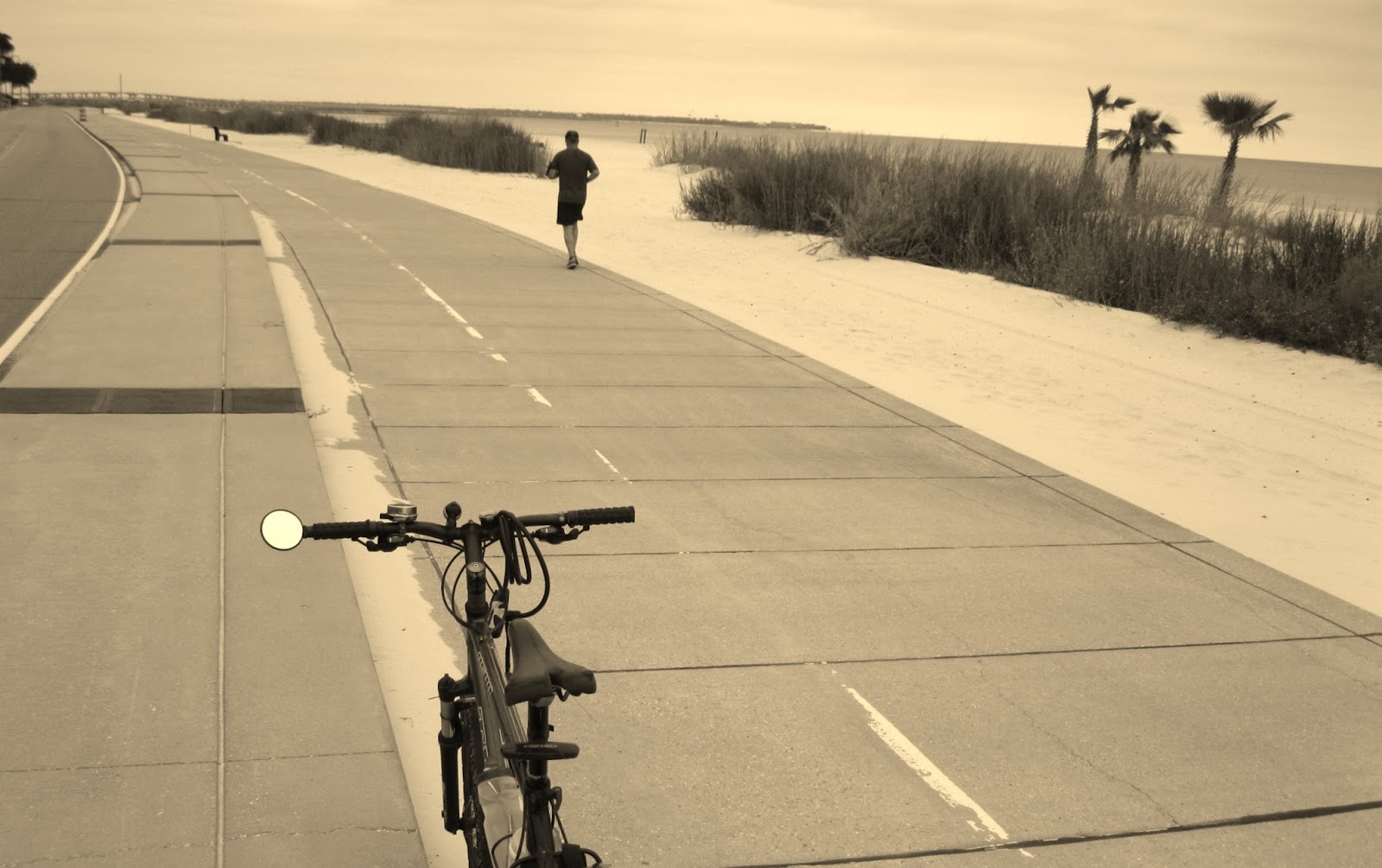 |
Looking east from wide concrete path between S. Beach St. and Mississippi Sound connecting Waveland and Bay St. Louis, Mississippi. The path is about four and one half miles long with parking at the Washington St. boat launch in Bay. St. Louis and the fishing pier in Waveland.
-30- |
The arrival of these occasional days of clear, crisp weather are an invitation to spend some time lazily bicycling through the coastal Mississippi towns of Bay St. Louis and Waveland. These two adjoining small beach towns fronting Mississippi Sound can be easily explored using self-propelled, two-wheel transportation. Almost all attractions; eateries, specialty shopping and museums in the two towns are within a few miles of each other and can be accessed using narrow but quiet residential streets or by riding a 4.5 mile paved path along the beach. Bicycling to the county's two casinos requires some cycling on two lane roads with moderate traffic.
But it's BYOB (Bring Your Own Bike) if you want to bicycle tour in Hancock Co. Fall is off-season so it will be hard to find a business renting bicycles there. Heck, its hard to find a bicycle to rent there in the middle of the popular summer season.
If you are comfortable riding with car traffic on a narrow two lane with no shoulders, check out Beach Blvd. From one end of the road at the mouth of the Jourdan River it's 12 miles to the Silver Slipper Casino overlooking the Sound. All along the way are a variety of marine vistas from the dunes tufted with sea oats swaying in the breezes to the wetlands alive with shore birds near the mouth of the river. This main road also fronts Buccaneer State Park with its popular wave pool. This is a great early Sunday morning trek.
The Bay-Waveland Beach Trail is a 4.5 mile paved path that parallels S. Beach Blvd. One end begins at the Washington St. Pier in Bay St. Louis. At 2.7 miles it passes the Waveland Pier and runs almost two miles past it west to a dead end. Join S. Beach Blvd. to continue riding west.
Take some time to get off the trail and ride up Coleman Ave. into "downtown" Waveland. Bay St. Louis and Waveland were ground-zero for the fury of Hurricane Katrina in 2005. A storm surge nearly three stories high came in from the Gulf of Mexico and smacked into the two towns. Buildings and homes were reduced to rubble and splinters-- many well inland from the shore--especially in Waveland. Note the large parcels of open land fronting S. Beach Blvd. Before August 29, 2005, there were homes on those lots.
An historic brick schoolhouse, the only building left standing on Coleman Ave. after the storm, has been restored and serves as a museum that tells the story of the storm and of the heroic effort of those living through it to rebuild the town. www.wavelandgroundzero.com/
Back in Bay St. Louis, make your way from from the Washington St. pier (boat launch, bathhouse and parking) to Depot Row on Blaize Ave. using Beach Blvd. and Union St. Across the street from the row of restaurants and shops is the historic L & N Railroad Depot. Built in 1928, the two story mission style depot was a busy place years ago when "The Bay" was a vacation destination for summer fun seekers from New Orleans, 60 miles to the west. Recently restored, the white depot with the hot pink trim, is now the home to the Depot Visitor Center and the Hancock County Tourism Development Bureau. Phone 228-463-9222 or 800-466-9848.
At the Depot you can find the Old Town Bay St. Louis Historic Walking and Biking Tour brochure, valuable for locating other attractions in Bay St. Louis.
Much of "This Property is Condemned," a 1966 movie based on a one-act play by Tennessee Williams, was filmed in Bay St. Louis. (A little of the movie was also filmed in New Orleans.) It featured a young Robert Redford and Natalie Wood in starring roles. Ask about the many buildings seen in the film that still exist. The Star Boarding House, featured in the film, has been restored and is now the home of the Bay St. Louis Little Theatre.
If your ride is on a Sunday check out the Jazz Brunch at LuLu Eats, 126 Main St., 228-466-6620. The live music packs the place on Sunday so call early to let them know you are coming.
-30-
Saturday, October 3, 2015
Possum Trail resurfaced with crushed stone yet still a hazardous bicycle ride
 |
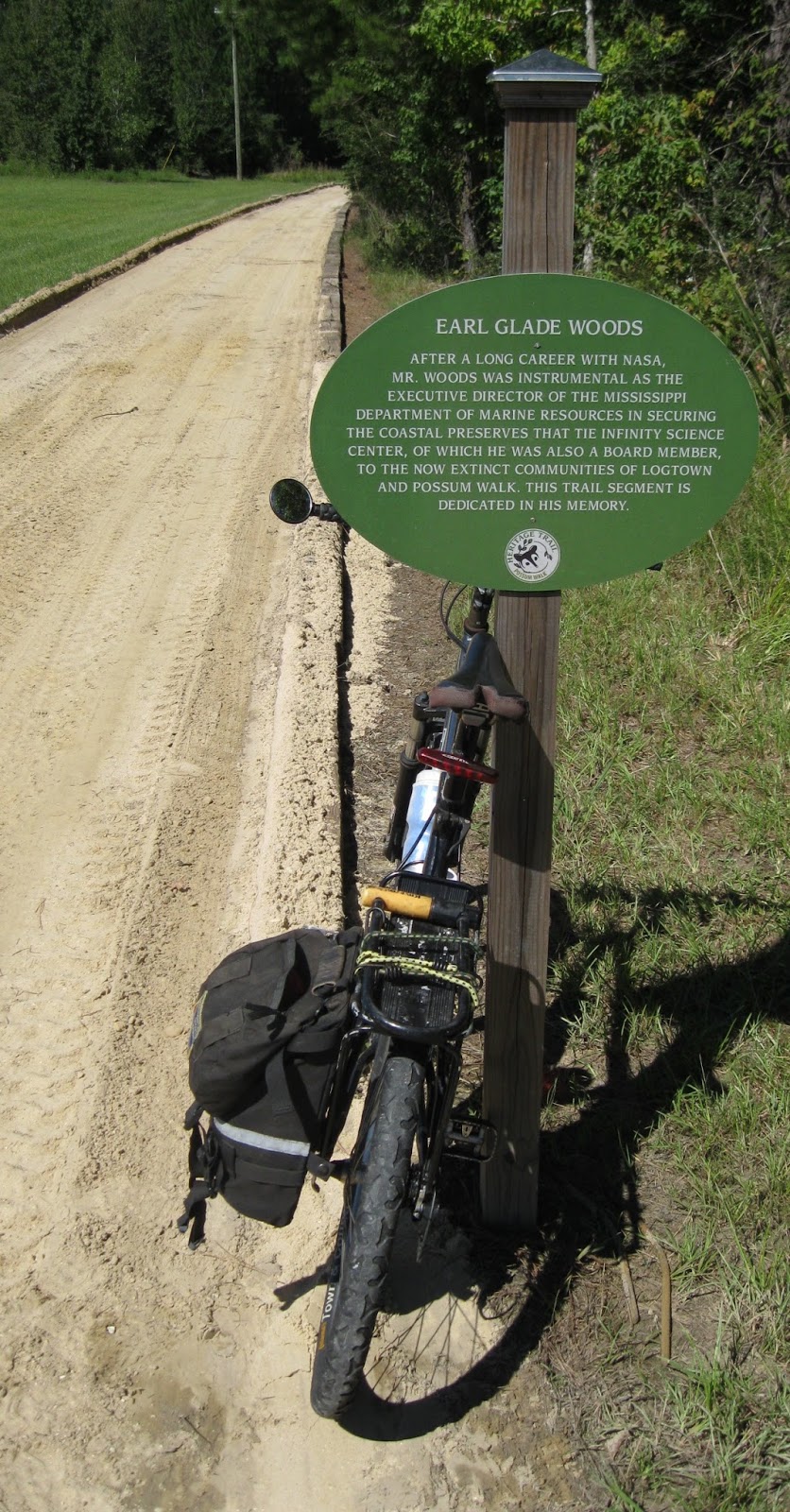
The Possum Walk Trail, from the historic Logtown town site to NASA's Infinity Science Center, was recently resurfaced with crushed stone. The trail attracts birding enthusiasts from around the US. Next year visitors to the Science Center will have the option to explore the trail riding in electric trams. (Picture taken October 3, 2015)
|
(Note: The Roadkill Run scheduled for October 10, 2015 was cancelled.)
In Hancock Co. MS, the Possum Walk Trail opened over a year ago as a graded dirt trail connecting the cemetery at the historic Logtown town site with the parking lot at the NASA Infinity Science Center 3.2 miles to the northeast. To ready the trail for electric trams that will carry Science Center tourists on nature treks on the trail in 2016, work began resurfacing the dirt trail with crushed stone in September. By Oct. 3 the work on the trail has progressed to the point users are now allowed back on the trail, though a short stretch near the boardwalk at the Logtown end of the trail still needs to be graded and resurfaced.
While the dirt surface was fine for walkers, runners, equestrians and the occasional golf cart, the soft dirt made riding a bicycle on the trail dicey. Even bicycle wheels with fat tires would sink into the powdered dirt making it difficult to steer without falling. Bicyclists had hoped the new crushed stone surface would open the trail to bicycle use by providing a harder surface to ride on.
The new surface is worse than the dirt. The coarsely crushed stone sits loose, like gravel, providing less traction for a bicycle tire than the dirt. And falling on the crushed stone could be more painful than falling on the dirt.
Not only is the new stone surface a hazard to those on two wheels, the loose stone presents a risk to those on two feet. Hikers, walkers, and trail runners should be careful when treading the shifting stone surface. Eventually the crushed stone will be pounded into the dirt underneath by the tires of the electric tourist trams, (and other motorized vehicles using the trail), smoothing the surface. Until then footing on the loose rock is iffy. If planning to walk the trail, popular with birdwatchers, be sure to wear sturdy shoes offering good ankle support.
The trams themselves could be a hazard when they are introduced next year into the mix of trail users. A tram ride will be included with every admission to the Science Center--adults $12. The trail is not that wide. Trams will have to be equipped with a warning device to alert walkers who will have to move to the edge of the trail and walk single-file to allow the tram to pass. The trail may be wide enough for two trams to pass abreast but it will be a tight squeeze. Other trail users will probably have to step off the trail to allow room. And how often will the trams run?
-30-
Monday, September 28, 2015
Covington, LA rivers may become "blueways."
 |
| A pontoon boat cruises past the shore of the Bogue Falaya Wayside Park in Covington, LA. The park is one access to a proposed "blueway" (paddle trail) that would include portions of the Bogue Falaya, Abita and Tchefuncte rivers. |
The area where the Tchefuncte, Bogue Falaya and Abita Rivers converge in Covington, LA., is closer to becoming St. Tammany Parish's first blueway or water trail*.
The latest draft of the Three Rivers Paddling Trail map was shown to about 30 St. Tammany residents and others, September 17, 2015, at the Christwood Retirement Center. The meeting was the latest in a series of public meetings to gather feedback on the proposed blueway.
The proposed map runs the trail down river on the Bogue Falaya River to its confluence with the Tchefuncte River and then up to First Avenue Park. The latest draft extends the trail on the Bogue Falaya upriver from Bogue Falaya Park. On the Tchefuncte the trail is extended past First Avenue Park. There is no access to the river at First Avenue Park but blueway supporters hope a kayak ramp can be built there. The Abita River, which flows into the Bogue Falaya is also included as a blueway.
Supporters say a map of a signed water trail will encourage canoe, kayak and paddle board enthusiasts to visit the streams for recreation. Also they hope the map will be a tool for environmental conservation and spur development of more public access to the three rivers.
Opinions given by participants of previous meetings and the observations of experienced paddlers who have recently traveled the rivers are helping map the route. The project is under the direction of the St. Tammany Parish's Department of Culture, Recreation and Tourism and is receiving assistance from The National Park Service's Rivers, Trails and Conservation Assistance Program (RTCA).
The project will serve as a model for developing similar trails in the rest St. Tammany Parish, Wensel Conroy, St. Tammany Parish's Department of Culture, Recreation and Tourism director told the gathering of paddlers and others from as faraway as New Orleans an Houma.
The group also heard from Rick Wilke, a Land Trust for Louisiana board member who said the private conservation organization came up with the idea of a blueway in the Covington area several years ago.
The Abita River and the Tchefuncte Rivers are included in Louisiana's Natural and Scenic Streams System. The Bogue Falaya River is under the protection of the scenic streams legislation, first passed in 1970, from the highway 437 bridge north of Covington upriver to its headwaters in Washington Parish.
Opinion:
Paddling the Bogue Falaya River (LA); Two miles of it anyway
by Jack Curry Jr.No need to wait for a "blueway" map to launch a canoe, kayak or paddle board into the three waterways under consideration for inclusion into the Three Rivers Paddling Trail. They can be paddled now. The Bogue Falaya, Tchefuncte and Abita rivers are attractive and easy to explore.
The lack of a current at normal water levels on the stretches of the three rivers under consideration for the blueway make out and back trips easy. No shuttle needed.
The scenery is typical south Louisiana: bottomland hardwood forest wetlands fringed with tall pine trees on the high ground. And urban too. Large developed waterfront lots, many with boat docks and boat houses are spaced by a jungle-like shoreline of tall pines and dense undergrowth; a scenic and peaceful place to fish, watch birds or just goof off.
When the weather is warm, all manner of kayaks, canoes, paddle boards and even inflatable rafts can be seen drifting on the broad section of the Bogue Falaya River between the Bogue Falaya Park and the Menetre boat launch at the end of Fourth St, two river-miles downriver.
The waterways under blueway consideration are also popular with motorboat owners. Between the park and the Menetre launch the river runs through several "no wake" zones calming the speeds of the variety of speedboats that like to travel the Bogue Falaya and Tchefuncte Rivers. But elsewhere on the Bogue Falaya River, except for upstream from the park where the river is normally too shallow to run an outboard motor, there are no speed limits. A plethora of speed boats, ski boats and personal watercraft can be heard hitting the gas as soon as they clear the last "no wake" zone and head down river from the Menetre launch, many on their way to Madisonville or Lake Pontchartrain ten miles away.
The exception to this waterborne Indy 500 is the Abita River where few motorboats venture far upstream because trees have fallen into the river blocking part of the channel. There are also a few hard to see black stumps in the channel.
Paddlers looking to spend as much time in the water as in their boats may be disappointed that while the dense vegetation growing to the water's edge might be pretty, it makes access to the banks very difficult and stepping out of a boat unwise. Downriver from the Boston St. bridge in Covington there is only one sandbar: the "beach" at Bogue Falaya Park. No swimming is permitted along the park's long shoreline and because the park closes at night there is no camping.
On the Abita River there are no sandbars where most paddlers are likely to go and none on the Tchefuncte River on the stretch favored by blueway planners.
Public Access
Access the Bogue Falaya River at Bogue Falaya Park near downtown Covington or at the boat launch two river-miles down stream at the end of Fourth St, (Menetre boat launch). This launch also provides public access to the Abita River and to the Tchefuncte River. At First St. Park there is a covered deck overlooking the Tchefuncte R. but no access to the water there.At Bogue Falaya Park, paddlers can carry from the parking lot about 50 yards to the water and launch from the sandy bank there.
From the park paddlers can go upstream or downstream. Upstream is the wilder stretch with thick woods growing to the water's edge. There is little evidence of human habitation. With each paddle stroke upstream the current strengthens as the water becomes shallow and assumes the tint of Southern sweet tea. Depending on your stamina sooner are later you will have to turn around and float back to the park. There is no public access to the Bogue Falaya upstream of Bogue Falaya Park.
Leaving the park and heading downstream paddlers will likely have to share the broad river with motorboat traffic. Paddlers may see a nicely restored classic wooden runabout or a family packed onto a pontoon boat for a weekend excursion but not much really fast marine traffic. There are several "no wake zones" in this stretch to slow hotshots down. The trip to the Menetre launch from the park is two miles, one-way.
At the Menetre launch there are several concrete boat launches, a smallish parking lot and a covered bench. No water or restrooms but the launch is free. Canoes and kayaks with tender hulls can be launched from the grassy shore.
To avoid high speed motorboat traffic after leaving the Menetre launch go upstream (turn left). Or veer right (downstream), cross the Bogue Falaya as quickly as possible to get out of the way of motorboat traffic there and on the east bank of the river look for the mouth of the Abita River, a bend or two from the launch.
This junction can be fun to explore. Drift among the marsh grass islands and peer at the shoreline hard enough and you might see a relic from the time steamboats brought freight and passengers up the Bogue Falaya R. from New Orleans to Covington.
The Abita River flows through a flood plain devoid of human intrusion, a surprisingly wild trip considering it is in the middle of one of the fastest growing parishes in Louisiana. Definitely a destination for nature lovers, bird watchers and solitude seekers. It may be the only one of the three rivers under consideration for blueway status that actually deserves it. (see Paddling the Abita River Nov. 4, 2015 in this blog.)
Canoes were rented when the Bogue Falaya Park was a state park years ago. Today kayaks can be rented from Brooks Bike Shop in downtown Covington, 985-237-3658. They also offer tours. They will deliver and pick-up from the Columbia Street Landing or you can take the boat where you want. They also have one paddle board for rent and are considering getting canoes. Kayak rental is also available in Lacombe, LA at Bayou Adventure. Massey's Performance Outfitters rents canoes and kayaks but only at their Mid-City New Orleans location. There are no public liveries on any of the three rivers in the Covington area.
Most canoeing guide books published in the last twenty have ignored the waterways in the proposed blueway. Neither the Bogue Falaya and Tchefuncte Rivers are even mentioned in the seminal "Canoe Trails of the Deep South," Estes, Carter and Almquist, published almost 25 years ago and long out of print. "Trail Guide to the Delta Country," Sevenair, last published by the New Orleans Group of the Sierra Club in 1997 and also out of print, does not mention the Bogue Falaya but includes a section of the Tchefuncte above US Hwy 190 (which is accessible only occasionally) as a "grim warning" of the high bacterial levels that can exist in a stream draining dairy farming country.
However, in the excellent "Canoeing Louisiana," Herndon, 2003 and still in print, Summit, MS author Ernest Herndon takes the opposite tack. Herndon gushes that the five miles of Bogue Falaya between LA 21 (E. Boston St.) and its confluence downstream with the Tchefunte is "glorious," citing the mix of hardwood forests along the banks and "grassy lawns reaching back to beautiful houses," as the attractions.
All of the Abita and Tchefuncte Rivers are included in the Louisiana Natural and Scenic Rivers System, created by the Louisiana Legislature in 1970. Only a portion of the Bogue Falaya is included: from the highway LA 437 bridge upstream to the river's headwaters in Washington Parish.
The river has its moods. The day I paddled the Bogue Falaya between Bogue Falaya Park and the Menetre launch, a USGS gauge at the E. Boston St. bridge was reading 1.76 feet. At this level the water lapped a short steep sand bank at the park and exposed a narrow sandbar. In the picture above, a pontoon boat is motoring upstream toward the Boston St. bridge.
But the river can get much higher. In May of 2015, a gauge reading of 6.52 feet, just above flood stage, brought flooding into the park. September, thirteen years ago, saw water levels rise to a disastrous 14 feet. Gauge readings can also go into minus numbers during very dry periods.
 |
| Parking for vehicles without trailers at the Menetre Park boat launch on the Bogue Falaya River at the end of Fourth St., Covington, LA. |
*Blueways aka water trails, are what canoe trails, float trails and paddle trails used to be called; smaller rivers, creeks and streams with features that appeal to paddling boaters such as; pretty scenery, lack of motorboat traffic, good fishing, public land for overnight camping, or just a place for goofing off away from common urban distractions. Establishing a "blueway" on any public body of water does not confer any legal status or special protections or exceptions. Anyone can call any stretch of water anywhere a "blueway".
-30-
Sunday, September 20, 2015
It's not official: The Lafitte Corridor bike path (New Orleans) is open
 |
| The paved path in the Lafitte Corridor as it crosses Jefferson Davis Parkway in New Orleans heading north. |
A 2.6 mile paved path passing through several neighborhoods between the French Quarter and City Park, is open.
The path runs through the Lafitte Corridor, a skinny park or greenway beginning at the north border of the French Quarter in New Orleans at Basin St. Station and ending at Alexander St. three blocks from City Park. There is parking at Basin St. Station but none at Alexander St.
Near the French Quarter the park is wide and there are ball fields and play areas near a public housing development. The corridor narrows after passing Broad St. The view of the derelict industrial area between Broad St. and Jefferson Davis Parkway is softened by freshly planted landscaping. There are lights along the length of the trail though some residents have lingering concerns about security.
Riders connecting the French Quarter with Mid-City and City Park also have the option of using the striped bike lane on Esplanade Ave. The striping stops about two blocks from the FQ leaving riders between a narrow traffic lane and solid on-street parking but there seems to be be more two wheel traffic using it than the Lafitte Corridor.
Maybe people don't know the Lafitte Corridor Tail is open. There has not yet been a ribbon cutting signaling the end of construction. yet people have been bicycling and walking it for about two months now. Almost every day or so workmen add something to it; a sign here, a fence there, a sprinkling of vegetation.
 |
| Can you find the blinking yellow lights? |
| Note: Expecting those little flashing amber lights to have any influence on the drivers traveling busy four and six-lane streets and avenues crossing the trail equals crazy here in New Orleans. As often noted in the Times Picayune, drivers here have long been proud of their reputation of ignoring crosswalks, striped or not. The amber flashing lights, (which, by the way, are hard to see in the daytime anyway) at the intersections of the trail and Carrollton Ave., Broad St., Jefferson Davis Parkway, Galvez St. and N. Claiborne are next to useless in stopping two or three lanes of approaching motorized traffic so you can cross. (Any driver stopping is probably from out of state.) Crossing the street when a car is coming is very dangerous. Wait until there is no traffic before crossing these busy streets. |
There is a deep crack on Broad St. a right angles to the path just as you come off the path heading north. It might spill a rider on a bicycle with skinny tires into traffic.
There is still landscaping work to do flanking the asphalt trail.
Several businesses of interest to bicyclists cluster near N. Carrollton. A high-end outdoor clothing retailer also selling camping gear and kayaks, sells bicycles and offers repairs. A bicycle shop, with an entrance off Toulouse St. backs up to the trail next to the post office. Neither shop rents bicycles. Two grocery stores with deli's and outdoor seating share the trail's property line.
Near the N. Carrollton intersection is a shopping center with a few trendy, inexpensive franchise eateries. (You can get your nails done too or buy a phone) You and your friends can celebrate your ride by having a burger, beer, tacos or frozen yogurt on the raised patio there.
-30-
Wednesday, September 16, 2015
New pop-up rents kayaks/canoes weekends on Bayou Bonfouca in Slidell, LA.
 |
| Camellia Kayaks and Canoes owner, Mitch Cry, at his stand in Heritage Park on Bayou Bonfouca |
-30-
Sunday, September 13, 2015
Possum Walk Trail near Pearlington, MS to reopen soon upgraded for bicycles with fat tires. 5k and 10k set for October 10.
 |
The beginning of the Possum Walk Trail before it was resurfaced with stone. This is the north end of the trail. It begins at the west end of the parking lot of the Infinity Space Center next to the Mississippi Visitors Center at the I-10 #2 exit near Waveland, MS.
|
For years the forested lowlands, wetlands and swamps in the southwest corner of Hancock County, Mississippi have attracted birdwatchers flocking to catch a glimpse of acrobatic swallow-tailed kites or tiny, and tuneful electric yellow prothonotary warblers.
The Logtown Cemetery, on Logtown Rd, south of I-10 is birding ground zero in the county and attracts the birding faithful from around the U.S. It is one of 40 birding sites listed on the Mississippi Coastal Birding Trail, sponsored by the National Audubon Society. The trail was established by widely respected birder, the late Judith Toups and includes sites in six of the southernmost counties in Mississippi. (www.mscoastbirdingtrail.audubon.org.)
A year ago the cemetery grounds became the southern terminus of the Possum Walk Trail: an improved and graded dirt trail extending north about 3.2 miles to the Infinity Science Center adjacent to the Mississippi Visitor Center off I-10 at exit #2. The trail passes through a mix of habitats: southern mixed hardwood forest, bottomland hardwood forest and cypress swamp. A boardwalk and bridge cross over the swamp and the Bogue Homa. A handicap accessible kayak launch is at the bridge.
As this is being written, the dirt trail is being resurfaced with crushed stone to prepare it for electric trams that will carry tourists from the Infinity Science Center on nature treks.. Work should finish and the trail reopen by early October 2015. In addition to walkers, hikers, runners and the trail is open to pet owners (as long as the pets are on leashes shorter than eight feet and owners deposit their pet's waste in garbage containers) and equestrians who are required to clean up waste left by their horses. Also electric carts are permitted. Bicyclists, even through riding bicycles with fat tires will probably find the crushed stone too lose making it possible for a cyclist to loose traction and fall while riding the trail.
The terrain is flat; the trail mostly follows an old dummyline railroad grade. Short railroads of a few miles or so were often built by lumber companies to haul harvested trees to the mills to be sawed into lumber. Some say they were called "dummylines" because logging employees often rode them along with the cut trees.
(The parking lot forthe Possum Walk Trail end at Infinity Science Center, generally opens at 7 a.m. and closes at 5 p.m. The lot, the Science Center and that end of the trail is closed on Sunday. The hours of the Infinity Science Center are from 9am to 4 pm., Monday-Saturday; closed on Sunday. Admission.)
However, the Logtown Cemetery end of the trail, is open sunrise to sunset, seven days a week. Park by pulling off the dirt road at the cemetery and walk .3 miles west on Logtown Rd.to the beginning of the boardwalk. This short stretch of Logtown Rd. is lovely and mostly in the shade of huge ancient live oaks. There is room at the boardwalk for a couple of cars to pull off the road but parking here is not encouraged. Posts a half mile apart measure distances on the trail. However it is difficult to determine exactly how long the trail is. The mile marker at the cemetery kiosk measures 3.2 miles from the Infinity Center to the cemetery. However, the brochure, "Birds of Logtown" available at the visitor center and the best map of the trail states the Possum Trail is 7.2 miles (probably a round trip distance,) Also the map in the brochure suggests a loop can be made by taking back roads to the Infinity Science Center. This is not worth the effort. Return to the Infinity Center by retracing your steps.
 |
| Kiosk at Logtown Cemetery |
The closest vehicle parking to the handicap accessible kayak launch on the Bogue Homa is Logtown Rd., about an eighth of a mile down the boardwalk from the ramp. The ramp may or may not be operational.
 |
| The handicap accessible kayak launch on the Bogue Homa off the Possum Walk Trail in Mississippi. |
When the trail opened a year ago, it quickly became popular with trail runners who used it to train for adventure races. The second annual Roadkill Run scheduled for Saturday, October 10, 2015 has been cancelled.
Trail named for long gone African-American settlement.
The cemetery is about the only remaining physical presence of Logtown, a once thriving, sawmill town that a hundred years ago was home to 2,000-3,000 people. Nothing of the houses, churches, school, store, boarding houses for mill workers, bank or post office remains. Gone are the large marina and docks on the Pearl River where hundreds of workers loaded lumber for shipment around the world. Gone the labyrinth of railroad tracks and smoky steam engines that hauled car after car of cut trees to the mill and then the lumber from them across the U.S. Hardly a trace is left of the sawmill itself, for years employing over 1,000 workers, 24-7 sawing the huge logs down to lumber.The Possum Walk Trail, gets its name from a small African-American community, once across Bayou Homa from Logtown. It is gone too. Possum is said to have been settled by escaped slaves who found the remote alligator and snake infested wetlands ideal for hiding from their owners. Later they were joined by former slaves freed after the Civil War ended in 1865. Later generations took jobs in the thriving lumber industry centered in Logtown across the bayou and home to one of the largest lumber mills in the world.

Largely depopulated by the mid 20th century (Logtown had about 250 people in 1961) the area around Logtown attracted the attention of the National Aeronautics and Space Administration (NASA). The agency was looking for a site to test rockets to power a spacecraft to land a man on the moon and return. In the process of establishing the Stennis Rocket Test site in the 1960s, a 125,000 acre acoustical buffer zone was created. Those still living in Logtown and other former logging towns in the buffer zone were relocated. Some sold their land to NASA outright. Others retained ownership of the land (any buildings were removed) but agreed to selling NASA a surface easement that prohibited the landowners from building or even camping on land they owned. All other land rights were retained by the landowners.
For more information about the Possum Walk Trail call the Infinity Science Center Visitor Center at 228-533-9025, or go to : www.visitinfinity.com. To view the "Birds of Logtown" brochure, visit www.unarch.com/practice/possum-walk-scenic-byways/ There is a gift shop in the visitor center. You can buy the same "ice cream" the astronauts eat on space flights there. A cafe in the Infinity Science Center Visitor Center is open for lunch Monday-Saturday, 11 am-3 p.m. Friday is pizza day. The cafe and the visitor center itself, are closed Sunday.
-30-
Subscribe to:
Posts (Atom)